December 19, 2025

How Annotated Aerial Imagery Supports Australia's Environmental Monitoring

As climate pressures grow, Australia is increasingly turning to environmental AI powered by annotated aerial and satellite imagery. From bushfire detection AI to coastal surveillance, labeled data from drones and satellites helps organizations monitor, predict, and protect vulnerable ecosystems. This article dives deep into how satellite annotation supports environmental resilience at scale across Australia's diverse landscapes.

Discover how satellite annotation and environmental AI detect bushfires, monitor biodiversity, and track Australia’s ecosystem sustainability.

How Annotated Aerial Imagery Supports Australia's Environmental Monitoring

Australia’s ecosystems are both incredibly rich and increasingly fragile. Climate change, bushfires, urban expansion, and land degradation are pressing issues—and responding to them requires precise, real-time data. Fortunately, the intersection of aerial data and environmental AI is unlocking new solutions.

With growing access to high-resolution imagery from satellites and drones, Australia is embracing AI-powered systems that help researchers and government agencies make faster, smarter decisions. But behind every successful AI for environmental monitoring is a foundation of carefully labeled data—otherwise known as satellite annotation or aerial image labeling.

This article unpacks how annotated aerial and satellite imagery supports AI across core environmental use cases—from bushfire detection AI to biodiversity mapping and illegal activity monitoring.

Why Environmental AI Needs High-Quality Satellite Annotation

At the core of every effective environmental AI system lies a deceptively simple requirement: clean, accurately labeled data. For AI to make sense of the world from above—whether from satellite constellations or drone flyovers—it must first learn what it's looking at. And that learning begins with high-quality satellite annotation.

Turning Pixels Into Intelligence

Raw satellite or aerial imagery is a dense mass of unstructured pixels. While it contains vast environmental insights, none of it is usable by AI until it’s broken down into human-verified categories through annotation. These annotations might include:

  • Land cover types (e.g., forests, urban zones, wetlands)
  • Water levels and coastlines
  • Fire scars and smoke plumes
  • Vegetation health indicators
  • Infrastructure like roads or mining pits

Each labeled feature becomes a training sample that teaches the AI model what patterns to recognize in future, unseen imagery. Without this, even the most advanced neural network is essentially blind.

Discover how our Satellite Image Annotation services enhance land mapping, deforestation tracking, and environmental analysis in large-scale projects.

The Backbone of Environmental Intelligence

In environmental applications, the stakes for poor labeling are high. A misclassified wetland could lead to the loss of a critical ecosystem. An unlabeled fire scar could skew a bushfire detection AI model. An over-annotated urban boundary could distort heat island projections.

By contrast, high-quality satellite annotation empowers environmental AI to:

  • Learn faster from smaller datasets, reducing training time and computational cost
  • Detect subtle changes in land use over time, such as illegal clearings or regrowth
  • Generalize better to new geographic areas, ensuring scalability across Australia’s diverse regions
  • Improve accuracy in life-critical applications like early wildfire alerts or flood modeling

For example, fire-prone regions in New South Wales use AI tools trained on annotated thermal and multispectral imagery to detect heat signatures and fuel loads—leading to faster deployment of firefighting resources. This system would be impossible without thousands of labeled frames outlining past fire perimeters and severity levels.

Temporal Annotation for Climate and Ecological Trends

Unlike single-image object detection, environmental AI often requires temporal annotation—labeling changes across time series imagery. This adds a layer of complexity but is vital for:

  • Tracking vegetation cycles over seasons
  • Measuring glacier retreat or lake shrinkage
  • Monitoring regrowth in post-burn environments
  • Detecting new urban sprawl in ecologically sensitive areas

These time-linked annotations enable AI models to understand not just what is happening, but how it’s changing. This capability is crucial for planning long-term climate resilience, conservation policies, and land use regulation.

Accuracy, Precision, and Domain Expertise

Effective satellite annotation for environmental monitoring goes beyond basic bounding boxes. It demands:

  • Pixel-perfect polygon segmentation for habitats, fire scars, and vegetation zones
  • Layered annotation, combining thermal, RGB, and LiDAR data sources
  • Expert input, often requiring collaboration with ecologists, fire scientists, or geospatial analysts

This is especially true for training AI to distinguish complex natural phenomena—like separating seasonal water bodies from permanent wetlands, or distinguishing controlled burns from wildfires in remote bushland.

Enabling Real-Time Environmental Action

Speed matters. In cases like bushfire detection AI, having a model trained on high-quality annotated satellite data can mean the difference between containment and catastrophe. Real-time inferencing depends on highly accurate datasets where the AI doesn’t second-guess whether a thermal anomaly is a harmless campfire or a spreading blaze.

Likewise, conservation AI tools monitoring endangered species habitats rely on regularly updated annotations that reflect recent land use changes. Without them, models risk missing encroachments or failing to detect habitat fragmentation.

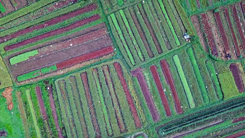
Vegetation and Land Use Monitoring with Annotated Imagery 🌱

Managing sustainable land use requires understanding both natural vegetation patterns and human impact. Annotated aerial data allows AI-driven monitoring of forests, deserts, croplands, and wetlands across Australia.

These labeled datasets enable environmental AI tools to:

  • Detect land clearing in real time
  • Monitor drought-affected areas and vegetation stress
  • Identify encroaching invasive species
  • Track agricultural expansion and its environmental footprint

This is especially relevant in semi-arid regions where satellite annotation helps distinguish between native flora and degraded lands, supporting restoration strategies and carbon offset verification.

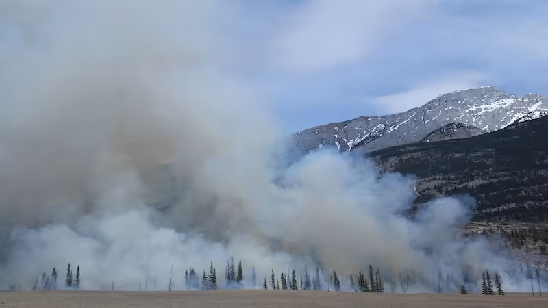
Bushfire Detection AI: A Lifesaving Use Case for Labeled Satellite Imagery 🔥

Among the most critical applications of environmental AI in Australia is early warning and damage analysis for wildfires.

With thousands of hectares lost annually to bushfires, bushfire detection AI uses annotated aerial imagery to:

  • Pinpoint high-risk zones before ignition
  • Track fire fronts with thermal satellite data
  • Assess burn severity and canopy loss
  • Predict spread behavior using historical burn patterns

The Australian Fire Danger Rating System and tools like CSIRO’s Spark rely on satellite annotation to model how bushfires evolve across different terrains. Thermal imagery, LiDAR data, and drone footage, when annotated with burn markers, help train AI models that now outperform manual monitoring systems in speed and scale.

These AI-powered insights are not just academic—they save lives, property, and ecosystems.

Coastal Surveillance and Marine Habitat Protection Using Environmental AI 🌊

Australia’s coastlines are both economically vital and ecologically sensitive. With over 34,000 km of coastline and significant marine biodiversity, continuous monitoring is essential.

Here’s where satellite annotation again plays a crucial role:

  • Identifying coral bleaching zones in the Great Barrier Reef
  • Detecting mangrove loss from coastal development
  • Monitoring storm surge damage and sea-level rise
  • Flagging illegal fishing in protected waters

AI models trained on labeled aerial data can distinguish subtle environmental signals, like sediment plumes or heat anomalies, before they escalate into irreversible damage. As a result, marine conservation groups and local governments are increasingly adopting environmental AI solutions for real-time decision-making.

Tracking Endangered Species and Ecosystem Health 🐨

Many of Australia’s native species—such as koalas, cassowaries, and greater gliders—face threats from habitat destruction and climate shifts. Traditional tracking is slow, labor-intensive, and often invasive.

With satellite annotation, researchers can train AI models to:

  • Spot animal clusters or tracks in drone footage
  • Identify critical habitat areas
  • Measure ecosystem connectivity and fragmentation
  • Predict biodiversity loss before it happens

These insights are used by national parks, conservation NGOs, and academic researchers to guide both protective legislation and field-based action plans. It’s another example where environmental AI outperforms older manual methods in scope and scalability.

Illegal Logging, Mining, and Land Clearing: AI as a Watchdog 🛰️

Illegal land use is difficult to detect—especially in remote areas. But AI models powered by annotated satellite data are increasingly adept at catching these violations early.

Use cases include:

  • Identifying forest loss in protected zones
  • Spotting unregistered mine expansions
  • Monitoring land clearing outside of legal bounds
  • Supporting law enforcement with visual evidence

With tools like Global Forest Watch and locally developed platforms, environmental protection agencies can automate oversight using environmental AI, reducing both response time and reliance on costly field inspections.

Climate Change Monitoring Through Long-Term Satellite Annotation

Tracking climate trends requires massive, consistent datasets. Satellite imagery offers a continuous visual archive of Australia’s changing environment—but only annotated datasets unlock its full value.

AI models built from long-term satellite annotation help detect:

  • Shifting rainfall patterns and vegetation cycles
  • Shrinking water bodies or glacial areas
  • Urban heat islands in sprawling cities
  • Erosion hotspots and infrastructure vulnerabilities

These insights feed into national climate strategies like the Australian Climate Service, empowering more accurate forecasts and better local-level policy responses. The future of environmental AI depends on this depth of high-quality, labeled data.

How Australian Startups and Researchers Leverage Environmental AI

A new generation of AI innovators in Australia is harnessing annotated aerial imagery to tackle pressing ecological issues. From startup accelerators to university labs, the ecosystem is booming.

Notable contributors include:

  • Earth AI: Using AI to identify low-impact mining sites with ecological foresight
  • Green Gravity: Optimizing renewable energy site selection with environmental overlays
  • UNSW and CSIRO: Collaborating on bushfire detection AI using multispectral satellite imagery

These projects typically depend on satellite annotation services that can label land use, burn zones, canopy types, or species-specific features. As demand grows, so does the need for expert annotation that can scale across multiple geographies and timeframes.

Scaling Sustainability with Precision: The Role of Geospatial Labeling Services

Whether for government-funded research or startup-driven solutions, reliable Image Annotation is non-negotiable. Especially in environmental AI, where the stakes range from biodiversity loss to human safety, labeled data must be:

  • Geospatially accurate and temporally consistent
  • Aligned with national cartographic standards
  • Compliant with open data and AI ethics guidelines
  • Reviewed by domain experts where possible

Trusted annotation partners help Australian organizations build datasets that feed AI systems with clarity and confidence—no guesswork involved.

If your use case involves farming or crop monitoring, check out our Agriculture Image Labeling to improve field-level insights. For custom aerial AI workflows, our Custom AI Projects team helps you prototype and scale reliably.

Looking Ahead: AI and Satellite Annotation for a Resilient Australia 💡

The path forward is clear. As environmental pressures mount, AI powered by annotated satellite data will be a cornerstone of Australia’s sustainability toolkit. From early bushfire detection AI to habitat restoration planning, the real-time, labeled insights derived from the sky will guide land management for decades to come.

Emerging technologies—such as hyperspectral imaging, swarms of autonomous drones, and real-time satellite streaming—will only deepen what’s possible. But the foundation will remain the same: clear, well-annotated imagery that teaches AI to see, understand, and protect the world we live in.

Want to Put Environmental AI Into Action?

Whether you’re building an AI model to predict wildfires, assess marine health, or enforce land protections, the right annotated imagery is your launchpad.

At DataVLab, we provide end-to-end satellite annotation and aerial image labeling tailored for environmental impact. We help Australian startups, researchers, and institutions accelerate their environmental AI projects—confidently and ethically.

🛰️ Let’s explore how we can help your vision take off—get in touch with us today.

Related Reading:

Let's discuss your project

We can provide realible and specialised annotation services and improve your AI's performances

Explore Our Different
Industry Applications

Our data labeling services cater to various industries, ensuring high-quality annotations tailored to your specific needs.

Data Annotation - AI & Computer Vision

Unlock the full potential of your AI applications with our expert data labeling tech. We ensure high-quality annotations that accelerate your project timelines.

Image Annotation

Enhance Computer Vision
with Accurate Image Labeling

Precise labeling for computer vision models, including bounding boxes, polygons, and segmentation.

Video Annotation

Unleashing the Potential
of Dynamic Data

Frame-by-frame tracking and object recognition for dynamic AI applications.

3D Annotation

Building the Next
Dimension of AI

Advanced point cloud and LiDAR annotation for autonomous systems and spatial AI.

Custom AI Projects

Tailored Solutions 
for Unique Challenges

Tailor-made annotation workflows for unique AI challenges across industries.

NLP & Text Annotation

Get your data labeled in record time.

GenAI & LLM Solutions

Our team is here to assist you anytime.

This is some text inside of a div block.

Scale AI Alternative

A Scalable, Transparent Alternative to Scale AI

A reliable, cost-effective alternative to Scale AI with transparent processes, expert annotators, and customizable workflows for computer vision, NLP, and multimodal AI.

Data Annotation Australia

Data Annotation Services for Australian AI Teams

Professional data annotation services tailored for Australian AI startups, research labs, and enterprises needing accurate, secure, and scalable training datasets.

Data Annotation New Zealand

Data Annotation Services for New Zealand AI Teams

Accurate, reliable, and scalable data annotation services tailored to New Zealand’s AI ecosystem, including agriculture, drone mapping, conservation, and smart-infrastructure applications.

Mechanical Turk Alternative

A Reliable, High-Quality Alternative to Amazon Mechanical Turk

A dependable alternative to Mechanical Turk for teams that need high-quality annotation, stable workforce management, and predictable results for AI and computer vision datasets.

Data Annotation Germany

Data Annotation Services for German AI Companies

Reliable, accurate, and GDPR-compliant data annotation services tailored for German AI startups, research institutions, and enterprise innovation teams.

Data Annotation Korea

Data Annotation Services for South Korean AI Companies

Accurate, scalable, and secure data annotation services tailored for South Korea’s rapidly advancing AI industry across robotics, semiconductors, autonomous mobility, medical imaging, and public safety.

Data Annotation France

Data Annotation Services for French AI Teams

Professional data annotation services tailored for French AI startups, enterprises, and research labs that require accuracy, reliability, and GDPR-compliant workflows.

Data Labeling Services

Data Labeling Services for AI, Machine Learning & Multimodal Models

End-to-end data labeling AI services teams that need reliable, high-volume annotations across images, videos, text, audio, and mixed sensor inputs.

Data Annotation Services

Data Annotation Services for Reliable and Scalable AI Training

Expert data annotation services for machine learning and computer vision, combining expert workflows, rigorous quality control, and scalable delivery.

Data Annotation Dubai

Data Annotation Services for AI Teams in Dubai and the UAE

Professional data annotation services tailored for Dubai’s fast-growing AI ecosystem, with high-accuracy workflows for computer vision, geospatial analytics, retail, mobility, and security applications.

Data Annotation USA

Data Annotation Services for U.S. AI Companies

Professional data annotation services for U.S. startups, enterprises, and research teams building high-performance AI models across diverse industries.

Data Annotation Europe

Data Annotation Services for European AI Teams

High-quality, secure data annotation services tailored for European AI companies, research institutions, and public-sector innovation programs.

Data Annotation Outsourcing Company

A Reliable Data Annotation Outsourcing Company for High Quality AI Training Data

A dedicated data annotation outsourcing company that delivers accurate, scalable, and secure labeling services for computer vision, multimodal AI, and enterprise machine learning workflows.

Outsourced Image Labeling Services

Outsourced Image Labeling Services for High Quality Computer Vision Training Data

Accurate and scalable outsourced image labeling services for computer vision, robotics, retail, medical imaging, geospatial intelligence, and industrial AI.

Data Labeling Outsourcing Services

Data Labeling Outsourcing Services for High Quality and Scalable AI Training Data

Professional data labeling outsourcing services that provide accurate, consistent, and scalable annotation for computer vision and machine learning teams.

Data Annotation for Startups

Flexible and High Quality Data Annotation Services for Startups Building AI Products

Affordable, fast, and scalable data annotation designed specifically for startups working on computer vision, multimodal AI, and rapid prototyping.

Enterprise Data Labeling Solutions

Enterprise Data Labeling Solutions for High Scale and Compliance Driven AI Programs

Enterprise grade data labeling services with secure workflows, dedicated teams, quality control, and scalable capacity for large and complex AI initiatives.

ML Outsourcing Services

ML Outsourcing Services for Scalable and High Quality AI Data Operations

Comprehensive ML outsourcing services that support data annotation, data preparation, quality control, enrichment, and human in the loop workflows for machine learning teams.

Semantic Segmentation Services

Semantic Segmentation Services for Pixel Level Computer Vision Training Data

High quality semantic segmentation services that provide pixel level masks for medical imaging, robotics, smart cities, agriculture, geospatial AI, and industrial inspection.

Bounding Box Annotation Services

Bounding Box Annotation Services for Accurate Object Detection Training Data

High quality bounding box annotation for computer vision models that need precise object detection across images and videos in robotics, retail, mobility, medical imaging, and industrial AI.

Polygon Annotation Outsourcing

Polygon Annotation Outsourcing for High Precision Computer Vision Datasets

High accuracy polygon annotation outsourcing for object boundaries, irregular shapes, and fine grained visual structures across robotics, retail, medical imaging, geospatial AI, and industrial inspection.

Polygon Annotation Services

Polygon Annotation Services for Precise Object Boundaries and Complex Visual Shapes

High accuracy polygon annotation for computer vision teams that require precise object contours across robotics, medical imaging, agriculture, retail, and industrial AI.

Computer Vision Annotation Services

Computer Vision Annotation Services for Training Advanced AI Models

High quality computer vision annotation services for image, video, and multimodal datasets used in robotics, healthcare, autonomous systems, retail, agriculture, and industrial AI.

Computer Vision Labeling Services

Computer Vision Labeling Services for High Quality AI Training Data

Professional computer vision labeling services for image, video, and multimodal datasets used in robotics, smart cities, healthcare, retail, agriculture, and industrial automation.

Object Detection Annotation Services

Object Detection Annotation Services for Accurate and Reliable AI Models

High quality annotation for object detection models including bounding boxes, labels, attributes, and temporal tracking for images and videos.

MRI Annotation Services

MRI Annotation Services for Brain, Musculoskeletal, and Soft Tissue Imaging AI

High accuracy MRI annotation for neuroimaging, musculoskeletal imaging, soft tissue segmentation, organ labeling, and research grade AI development.

Medical Video Annotation Services

Medical Video Annotation Services for Surgical AI, Endoscopy, and Ultrasound Motion Analysis

High precision video annotation for surgical workflows, endoscopy, ultrasound sequences, and medical procedures requiring temporal consistency and detailed labeling.

Medical Image Annotation Services

Medical Image Annotation Services for Radiology, Pathology, and Clinical Imaging AI

High accuracy annotation for MRI, CT, X-ray, ultrasound, and pathology imaging used in diagnostic support, research, and medical AI development.

Ultrasound Annotation Services

Ultrasound Annotation Services for Diagnostic Imaging, Motion Analysis, and Clinical AI

High precision annotation for ultrasound imaging across abdominal, vascular, cardiac, obstetric, and musculoskeletal applications.

Medical Annotation Services

Medical Annotation Services for Imaging, Diagnostics, and Clinical AI Development

High quality medical annotation services for AI teams building diagnostic support tools, imaging models, and healthcare automation systems.

X-ray Annotation Services

X-ray Annotation Services for Chest, Skeletal, and Diagnostic Imaging AI

High quality X-ray annotation for chest imaging, bone structures, detection models, and diagnostic support systems across clinical applications.

Radiology Image Annotation Services

Radiology Image Annotation Services for MRI, CT, X-ray, and Advanced Diagnostic AI

High accuracy annotation for radiology imaging including MRI, CT, X-ray, PET, and specialized scans used in diagnostic support and medical AI development.

Medical Text Annotation Services

Medical Text Annotation Services for Clinical NLP, Document AI, and Healthcare Automation

High quality annotation for clinical notes, reports, OCR extracted text, and medical documents used in NLP and healthcare AI systems.

Medical Waveform Annotation Services

Medical Waveform Annotation Services for ECG, EEG, EMG, and Physiological Signal AI

High precision annotation of ECG, EEG, EMG, and other biomedical waveforms for clinical research and AI model development.

Diagnosis Annotation Services

Diagnosis Annotation Services for Clinical AI, Imaging Models, and Decision Support Systems

Structured annotation of diagnostic cues, clinical findings, and medically relevant regions to support AI development across imaging and clinical datasets.

Pathology Annotation Services

Pathology Annotation Services for Whole Slide Imaging, Histology, and Cancer Research AI

High accuracy annotation for pathology and microscopy datasets including whole slide images, tissue regions, cellular structures, and oncology research features.

Medical Data Labeling Services

Medical Data Labeling Services for Imaging, Text, Signals, and Multimodal Healthcare AI

High quality labeling for medical imaging, clinical documents, biosignals, and multimodal datasets used in healthcare and biomedical AI development.

ADAS and Autonomous Driving Annotation Services

ADAS and Autonomous Driving Annotation Services for Perception, Safety, and Sensor Understanding

High accuracy annotation for autonomous driving, ADAS perception models, vehicle safety systems, and multimodal sensor datasets.

3D Cuboid Annotation Services

3D Cuboid Annotation Services for Autonomous Driving, Robotics, and 3D Object Detection

High precision 3D cuboid annotation for LiDAR, depth sensors, stereo vision, and multimodal perception systems.

3D Point Cloud Annotation Services

3D Point Cloud Annotation Services for Autonomous Driving, Robotics, and Mapping

High accuracy point level labeling, segmentation, and object annotation for LiDAR and 3D perception datasets.

Sensor Fusion Annotation Services

Sensor Fusion Annotation Services for Multimodal ADAS and Autonomous Driving Systems

Accurate annotation across LiDAR, camera, radar, and multimodal sensor streams to support fused perception and holistic scene understanding.

LiDAR Annotation Services

LiDAR Annotation Services for Autonomous Driving, Robotics, and 3D Perception Models

High accuracy LiDAR annotation for 3D perception, autonomous driving, mapping, and sensor fusion applications.

Automotive Image Annotation Services

Automotive Image Annotation Services for ADAS, Autonomous Driving, and Vehicle Perception Models

High quality annotation for automotive camera datasets, including object detection, lane labeling, traffic element segmentation, and driving scene understanding.

Geospatial Data Annotation Services

Geospatial Data Annotation Services for Remote Sensing, Mapping, and Environmental AI

High quality annotation for satellite imagery, aerial imagery, multispectral data, LiDAR surfaces, and GIS datasets used in geospatial and environmental AI.

Satellite Image Annotation Services

Satellite Image Annotation Services for Remote Sensing, Land Use Mapping, and Environmental AI

High accuracy annotation for satellite imagery across land cover mapping, object detection, agricultural monitoring, and environmental change analysis.

Map Annotation Services

Map Annotation Services for GIS Platforms, Mapping Automation, and Cartography AI

Accurate annotation for digital maps, GIS layers, boundaries, POIs, road networks, and 2D cartographic datasets.

Traffic Labeling Services

Traffic Labeling Services for Smart City Analytics, Vehicle Detection, and Urban Mobility AI

High accuracy labeling for traffic videos and images, supporting vehicle detection, pedestrian tracking, congestion analysis, and smart city mobility insights.

Surveillance Image Annotation Services

Surveillance Image Annotation Services for Security, Facility Monitoring, and Behavioral AI

High accuracy annotation for CCTV, security cameras, and surveillance footage to support object detection, behavior analysis, and automated monitoring.

Crowd Annotation Services

Crowd Annotation Services for Public Safety, Density Mapping, and Behavioral Analytics

High accuracy crowd annotation for people counting, density estimation, flow analysis, and public safety monitoring.

Retail Data Annotation Services

Retail Data Annotation Services for In Store Analytics, Shelf Monitoring, and Product Recognition

High accuracy annotation for retail images and videos, supporting shelf monitoring, product recognition, people flow analysis, and store operations intelligence.

Retail Video Annotation Services

Retail Video Annotation Services for In Store Analytics, Shopper Behavior, and Operational Intelligence

High accuracy annotation of in store video feeds for shopper tracking, queue detection, planogram monitoring, and retail operations optimization.

eCommerce Data Labeling Services

eCommerce Data Labeling Services for Product Catalogs, Attributes, and Visual Search AI

High accuracy annotation for eCommerce product images, attributes, categories, and content used in search and catalog automation.

Retail Image Annotation Services

Retail Image Annotation Services for Product Recognition, Shelf Intelligence, and Merchandising Analytics

High accuracy annotation for retail product images, shelf photos, planogram audits, and merchandising scans.

Logistics Data Annotation Services

Logistics Data Annotation Services for Warehouse Automation, Robotics, and Supply Chain AI

High accuracy annotation for logistics images and video, supporting warehouse automation, parcel tracking, robotics perception, and supply chain analytics.

Industrial Data Annotation Services

Industrial Data Annotation Services for Manufacturing, Robotics, and Quality Control AI

High accuracy annotation for industrial vision systems, supporting factory automation, defect detection, robotics perception, and process monitoring.

Insurtech Data Annotation Services

Insurtech Data Annotation Services for Underwriting, Risk Models, and Claims Automation

High accuracy annotation for insurance documents, claims data, property images, vehicle damage, and risk assessment workflows used by modern Insurtech platforms.

Insurance Image Annotation for Claims Processing

Insurance Image Annotation for Claims Processing, Damage Assessment, and Fraud Detection

High accuracy annotation of vehicle, property, and disaster damage images used in automated claims processing, repair estimation, and insurance fraud detection.

Plant Annotation Services

Plant Annotation Services for Phenotyping, Disease Detection, and Agronomy Research

High precision plant level annotation for leaf segmentation, disease detection, phenotyping, growth analysis, and scientific agriculture datasets.

Agriculture Data Annotation Services

Agriculture Data Annotation Services for Farming AI, Crop Monitoring, and Field Analytics

High accuracy annotation for farming images, drone and satellite data, crop monitoring, livestock analysis, and precision agriculture workflows.

Agritech Data Annotation Services

Agritech Data Annotation Services for Precision Agriculture, Robotics, and Environmental AI

High accuracy annotation for agritech applications including precision farming, field robotics, multispectral analytics, yield prediction, and environmental monitoring.

Robotics Data Annotation Services

Robotics Data Annotation Services for Perception, Navigation, and Autonomous Systems

High precision annotation for robot perception models, including navigation, object interaction, SLAM, depth sensing, grasping, and 3D scene understanding.

Autonomous Flight Data Annotation Services

Autonomous Flight Data Annotation Services for Drone Navigation, Aerial Perception, and Safety Systems

High accuracy annotation for autonomous flight systems, including drone navigation, airborne perception, obstacle detection, geospatial mapping, and multi sensor fusion.

Maritime Data Annotation Services

Maritime Data Annotation Services for Vessel Detection, Surveillance, and Ocean Intelligence

High accuracy annotation for maritime computer vision, including vessel detection, port monitoring, EO and IR imagery labeling, route analysis, and maritime safety systems.

Financial Data Annotation Services

Financial Data Annotation Services for Fraud Detection, Risk Models, and Document Intelligence

High quality annotation for financial documents, transactions, statements, contracts, and risk data used in fraud detection and financial AI models.

Legal Document Annotation Services

Legal Document Annotation Services for Contract Intelligence, Clause Classification, and Compliance Automation

High quality annotation for contracts, legal documents, clauses, entities, and regulatory content used in LegalTech and document automation systems.

Real Estate Image and Floor Plan Annotation Services

Real Estate Image and Floor Plan Annotation Services for Property Intelligence and Room Classification

High accuracy annotation for real estate images and floor plans, including room classification, interior feature labeling, layout analysis, and property intelligence.

Image Tagging and Product Classification Annotation Services

Image Tagging and Product Classification Annotation Services for E Commerce and Catalog Automation

High accuracy image tagging, multi label annotation, and product classification for e commerce catalogs, retail platforms, and computer vision product models.

NLP Data Annotation Services

NLP Data Annotation Services for Language Models and Conversational AI

High quality NLP data labeling for intent detection, entity extraction, classification, sentiment analysis, and conversational AI training.

Text Data Annotation Services

Text Data Annotation Services for Document Classification and Content Understanding

Reliable large scale text annotation for document classification, topic tagging, metadata extraction, and domain specific content labeling.

LLM Data Labeling and RLHF Annotation Services

LLM Data Labeling and RLHF Annotation Services for Model Fine Tuning and Evaluation

Human in the loop data labeling for preference ranking, safety annotation, response scoring, and fine tuning large language models.

OCR and Document AI Annotation Services

OCR and Document AI Annotation Services for Structured Document Understanding

Annotation for OCR models including text region labeling, document segmentation, handwriting annotation, and structured field extraction.

Fitness AI Data Annotation Services

Fitness AI Data Annotation Services for Posture, Movement, and Exercise Recognition

High quality annotation services for fitness AI models including posture correction, movement tracking, exercise recognition, and form quality scoring.

Sports Video Annotation Services

Sports Video Annotation Services for Player Tracking and Performance Analysis

High precision video annotation for sports analytics including player tracking, action recognition, event detection, and performance evaluation.

Multimodal Annotation Services

Multimodal Annotation Services for Vision Language and Multi Sensor AI Models

High quality multimodal annotation for models combining image, text, audio, video, LiDAR, sensor data, and structured metadata.

Fashion Image Annotation Services

Fashion Image Annotation Services for Apparel Recognition and Product Tagging

High quality fashion image annotation for apparel detection, product tagging, segmentation, keypoint labeling, and catalog automation.

AR Annotation Services

AR Annotation Services for Gesture and Spatial AI

High accuracy AR annotation for gesture recognition, motion tracking, and spatial computing models.

Video Annotation Outsourcing Services

Video Annotation Outsourcing Services for Computer Vision Teams

Scalable human in the loop video annotation for tracking, action recognition, safety monitoring, and computer vision model training.

Drone Data Labeling

Drone Data Labeling

Multi modality drone data labeling for video, telemetry, LiDAR, and sequence based AI models.

Drone Image Annotation

Drone Image Annotation

High accuracy annotation of drone captured images for inspection, construction, agriculture, security, and environmental applications.

Aerial Image Annotation

Aerial Image Annotation

High quality annotation of aerial photography for mapping, inspection, agriculture, construction, and environmental analysis.

Audio Annotation

Audio Annotation

End to end audio annotation for speech, environmental sounds, call center data, and machine listening AI.

Speech Data Annotation

Speech Data Annotation

Speech labeling for ASR, speaker diarization, voice AI & language model training

Image Annotation Services

Image Annotation Services

Image annotation services for training computer vision and AI systems, with scalable workflows, expert QA, and secure data handling.

Video Annotation

Video Annotation Services for Motion, Behavior, and Object Tracking Models

High quality video annotation for AI models that require tracking, temporal labeling, event detection, and scene understanding across dynamic environments.

3D Annotation Services

3D Annotation Services for LiDAR, Point Clouds, and Advanced Perception Models

3D annotation services for LiDAR, point clouds, depth maps, and multimodal perception systems used in robotics, autonomy, smart cities, mapping, and industrial AI.

Custom AI Projects

Tailored Solutions for Unique Challenges

End-to-end custom AI projects combining data strategy, expert annotation, and tailored workflows for complex machine learning and computer vision systems.

GenAI Annotation Solutions

GenAI Annotation Solutions for Training Reliable Generative Models

Specialized annotation solutions for generative AI and large language models, supporting instruction tuning, alignment, evaluation, and multimodal generation.