Satellite image segmentation refers to the process of assigning each pixel in an aerial or satellite image to a specific class. These classes can represent land types, infrastructure, environmental features, or specialized objects depending on the project. Unlike bounding box detection, segmentation provides a complete understanding of scene structure. This is essential because satellite imagery contains significant complexity, and interpreting it requires fine grained spatial reasoning. Segmentation allows AI models to separate different land features with high precision, enabling reliable analysis on large geographic scales.
The rapid expansion of Earth observation programs has fueled greater interest in segmentation techniques. With more satellites capturing high resolution imagery than ever before, organizations need scalable methods to extract meaning from massive image archives. Open research from the European Space Agency (ESA) describes how segmentation algorithms are transforming applications across climate monitoring, land use analysis, and disaster response. These developments illustrate how segmentation is becoming a foundational capability in geospatial intelligence.
Why Satellite Image Segmentation Matters
Understanding land cover and land use
Segmentation helps classify land into categories such as vegetation, water, soil, urban areas, and agricultural fields. This supports land management, urban planning, environmental modeling, and regional development strategies. Without segmentation, analysts must rely on manual interpretation, which is time consuming and prone to inconsistency.
Building environmental monitoring systems
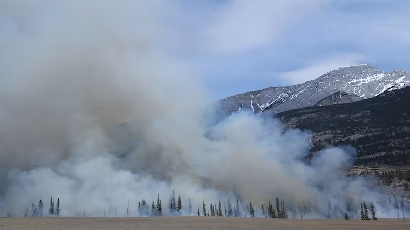
Government agencies and NGOs rely on segmentation to track deforestation, drought conditions, wildfire spread, coastline erosion, and other environmental changes. These monitoring efforts require consistent pixel level analysis across time, making segmentation indispensable for long term environmental insights.
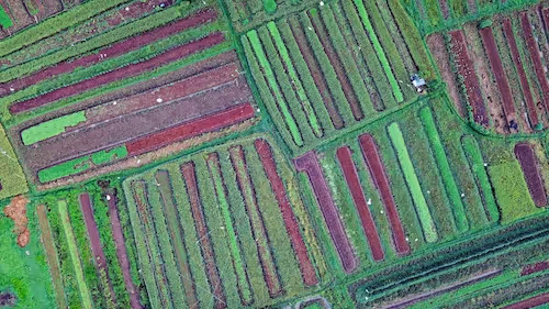
Supporting agriculture and food security
Crop mapping, yield prediction, irrigation analysis, and field boundary extraction all rely on segmentation. When combined with multispectral imagery, segmentation allows precise identification of crop health, soil moisture, and vegetation stress. Research from the International Food Policy Research Institute highlights how satellite based segmentation improves agricultural resilience and climate adaptation programs.
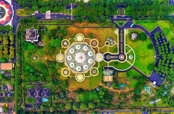
Enabling urban and infrastructure planning
Segmentation helps identify roads, buildings, parking lots, rooftops, and construction activity. City planners use this information to model urban expansion, optimize transportation networks, and manage utilities. The accuracy and scale of segmentation make it ideal for monitoring large metropolitan regions.
Driving renewable energy applications
Solar farm detection, rooftop panel identification, and site suitability analysis rely heavily on segmentation. Solar energy companies use segmentation to assess rooftops, estimate surface area, and evaluate installation feasibility.
Segmentation therefore touches nearly every sector that uses satellite imagery. It provides structured intelligence that enables better planning, monitoring, and decision making.
How Satellite Image Segmentation Works
Step 1: Image acquisition
Segmentation begins with acquiring satellite or aerial images. These images may come from commercial multispectral satellites, government missions, or drone based platforms. Image quality, resolution, and spectral bands all influence the segmentation pipeline. Analysts typically process data from optical or multispectral sensors, though radar and thermal sensors may also be included for advanced use cases.
Step 2: Pre processing
Satellite imagery requires significant preparation before segmentation. Pre processing may include radiometric corrections, atmospheric adjustments, cloud removal, and normalization of spectral channels. These steps ensure that the input data remains consistent even when comparing images from different seasons or sensor types. Quality pre processing often has a dramatic impact on segmentation accuracy.
Step 3: Feature extraction
Deep learning models analyze spatial patterns, spectral signatures, and textural features. For example, vegetation tends to exhibit distinct spectral characteristics, while buildings show sharp edges and strong geometric structure. The combination of spectral and spatial cues enables models to differentiate between land categories with high precision.
Step 4: Pixel level classification
The model assigns each pixel to a semantic class based on the features extracted. This results in a segmentation mask where every part of the image is labeled. Modern architectures support multi class segmentation and can handle complex geospatial scenes with many categories.
Step 5: Refinement and post processing
Post processing techniques smooth boundaries, correct edge artifacts, and ensure topological consistency. Some workflows also incorporate geographic constraints or morphological filters to refine the final output.
Segmentation is therefore a sophisticated pipeline that blends pre processing, deep neural architecture design, and geospatial post processing to produce high quality maps.

Semantic Segmentation of Aerial Imagery
Semantic segmentation is the most common segmentation approach in remote sensing. It labels each pixel according to its semantic meaning, making it ideal for land cover classification and scene understanding.
Fine grained pixel classification
In aerial imagery, small details play a major role in interpretation. Roads, roofs, trees, and water bodies often appear next to each other at high resolution. Pixel level classification captures these subtle distinctions far better than bounding boxes.
Handling spectral diversity
Satellite images include multiple spectral bands such as near infrared, red edge, and thermal. Semantic segmentation can incorporate these channels naturally, enabling the model to use spectral signatures along with spatial features. This is essential in agricultural and environmental applications where spectral information is more discriminative than shape alone.
Addressing multi scale complexity
Satellite imagery contains objects of vastly different scales. Buildings, fields, rivers, and forest patches require multi scale processing. Semantic segmentation architectures use skip connections, pyramid modules, and multi stage decoding to handle scale variation effectively.
Supporting time series segmentation
Monitoring changes across time requires consistent segmentation of multi date imagery. Temporal segmentation models ensure that the same areas receive consistent labels across seasons and years. This is fundamental for deforestation tracking and agricultural monitoring.
Semantic segmentation is one of the most widely adopted frameworks in satellite AI because it provides detailed, interpretable results suitable for mapping, environmental science, and infrastructure analysis.
Deep Learning Models for Satellite Image Segmentation
U Net and encoder decoder architectures
U Net and its derivatives remain the most common segmentation models in remote sensing. Their encoder decoder structure extracts deep features while preserving spatial detail. Variants such as U Net++ or Attention U Net improve boundary capture and robustness to noise.
DeepLab based architectures
DeepLab integrates dilation and multi scale feature extraction, making it effective for complex geospatial patterns. It handles irregular shapes and subtle boundaries particularly well. Many remote sensing teams rely on DeepLab for its ability to model fine structures and large contextual regions simultaneously.
SegFormer and transformer based models
Transformers have grown rapidly in popularity because they capture long range dependencies better than CNNs. SegFormer and other transformer based models perform exceptionally well in large scale segmentation tasks by modeling global context. Their ability to integrate spatial structure and spectral information makes them increasingly relevant to remote sensing.
Hybrid spatial spectral networks
Some models incorporate both spatial convolution and spectral attention. This approach is ideal for multispectral or hyperspectral imagery where spectral signatures carry important information. These hybrid models are particularly effective for agricultural and environmental analysis.
Self supervised and weakly supervised methods
Due to the scarcity of labeled geospatial datasets, researchers increasingly explore self supervised learning. Techniques such as contrastive learning enable models to learn useful representations from unlabeled imagery before fine tuning on small annotated datasets. The IEEE Geoscience and Remote Sensing Society has published extensive work on these advancements.
Model selection therefore depends on the dataset, resolution, spectral channels, and operational constraints.
Datasets for Satellite Image Segmentation
Multispectral datasets
Many segmentation projects use multispectral datasets with red, green, blue, and near infrared channels. These datasets support vegetation analysis, land cover mapping, and water detection. Multispectral images are available from government missions, commercial providers, or open Earth observation services.
Hyperspectral datasets
Hyperspectral datasets contain hundreds of bands. They provide extremely detailed spectral information that supports crop classification, mineral exploration, and environmental chemistry. Annotating hyperspectral datasets is challenging but yields highly accurate results.
High resolution aerial datasets
Aerial surveys provide higher resolution than satellites and are common in urban mapping, infrastructure planning, and utility analysis. These datasets require dense pixel level annotation to ensure accurate segmentation.
Cloud and shadow datasets
Clouds and shadows significantly affect segmentation accuracy. Many real world datasets include labels for clouds, cloud shadows, and atmospheric distortions. These classes are important for filtering noise and improving segmentation models.
Time series datasets
Monitoring temporal changes requires datasets with multiple captures of the same region across seasons. These datasets support deforestation analysis, crop rotation detection, and long term land use modeling.
External repositories such as the Radiant Earth Foundation MLHub provide high quality public satellite datasets that facilitate research and model benchmarking.
Annotation for Satellite Image Segmentation
Semantic segmentation masks
Annotators draw pixel wise masks that label each class. This is the foundational annotation type for geospatial segmentation projects. It requires specialized tools and trained annotators due to the complexity and density of satellite imagery.
Polygon annotation for large structures
For buildings, fields, lakes, or other large contiguous regions, polygon annotation can serve as an efficient alternative to full pixel masks. Polygons create well defined region boundaries suitable for downstream segmentation refinement.
Class hierarchy labeling
Some segmentation tasks use hierarchical labels, such as vegetation subdivided into crops, forests, and shrubland. Annotators must understand the hierarchy to apply consistent labels across the entire dataset.
Quality control and multi reviewer validation
Satellite imagery annotation often requires two or more reviewers per mask. Dense scenes increase the risk of labeling inconsistencies. Geospatial annotation workflows typically include automated checks for topology, class consistency, and mask boundary accuracy.
Spectral assisted annotation
Annotators sometimes rely on multispectral visualizations to distinguish confusing classes. For example, false color composites reveal vegetation health more clearly than RGB imagery alone.
Quality annotation is the backbone of segmentation accuracy. Without precise pixel level masks, segmentation models struggle to generalize across regions and seasons.
Challenges in Satellite Image Segmentation
Class imbalance
Some classes such as buildings or roads occupy far less area than vegetation or soil. Models may overfit to dominant classes unless carefully balanced datasets and loss functions are used.
Clouds, shadows, and weather variability
Clouds obscure large parts of satellite images. Shadows distort spectral signatures and boundaries. Models must learn to skip or reclassify these regions consistently.
Seasonal variation
Vegetation changes dramatically across seasons. To generalize well, models must train on multi seasonal data that represents these changes.
Sensor differences
Images from different satellites have varying resolutions, spectral bands, and noise patterns. Domain adaptation techniques help models transfer across sensor types.
Spatial heterogeneity
Regions differ in land cover complexity. Dense urban environments pose different segmentation challenges compared to agricultural regions. Geospatial datasets must capture this variation to avoid regional performance drops.
These challenges illustrate why segmentation pipelines require robust datasets and rigorous model training.
Real World Applications of Satellite Image Segmentation
Environmental conservation
Segmentation supports deforestation detection, wetland mapping, coastline monitoring, and biodiversity protection. Conservation organizations use segmentation to detect illegal logging or track natural habitat shifts.
Agriculture and crop management
Farmers and agritech companies rely on segmentation for crop health analysis, pest detection, irrigation optimization, and field boundary extraction. The Food and Agriculture Organization of the United Nations highlights how remote sensing segmentation enhances global agricultural monitoring programs.
Urban development and infrastructure
Segmentation maps buildings, roads, drainage networks, and construction activity. It helps cities update maps, plan zoning decisions, and optimize transportation layouts.
Energy and utilities
Utilities use segmentation to detect solar panels, analyze rooftop surfaces, and model terrain for energy infrastructure. Geospatial AI helps energy companies expand renewable energy capacity using precise land assessments.
Disaster response
Flood mapping, wildfire spread analysis, and damage assessment rely heavily on segmentation. After natural disasters, segmentation helps responders prioritize affected areas.
Segmentation transforms raw satellite pixels into actionable intelligence that directly supports operational decision making.
Future Directions
Self supervised geospatial models
Self supervised learning will reduce reliance on expensive labeled data. Models will learn from unlabeled satellite archives before fine tuning on small annotated datasets.
Foundation models for remote sensing
Large scale transformer models trained on global satellite data will enable universal geospatial understanding. These models will support multiple tasks including segmentation, detection, classification, and forecasting.
On device inference
With increased computing capabilities in edge hardware, segmentation models may run directly on satellites or drones. This allows on orbit processing and faster delivery of insights.
Climate aware segmentation models
Future models will explicitly incorporate environmental variables such as temperature, precipitation, and soil moisture to improve predictive power.
Multimodal integration
Combining satellite imagery with meteorological data, ground truth measurements, and socioeconomic information will generate richer decision support systems.
The future of segmentation lies in combining scale, automation, and advanced learning frameworks to unlock deeper insights from global geospatial data.
Conclusion
Satellite image segmentation is a fundamental capability in geospatial AI that enables organizations to interpret complex aerial and satellite imagery with high precision. By providing pixel level understanding, segmentation supports environmental conservation, agricultural monitoring, disaster response, urban development, and renewable energy planning. Building accurate segmentation models requires strong pre processing workflows, diverse datasets, high quality annotation, and well designed deep learning architectures. As the volume of Earth observation data accelerates, segmentation will continue to play a central role in transforming raw imagery into structured, actionable intelligence.