Geospatial mapping refers to the practice of collecting geographic data and visualizing it in maps that represent real world locations. The goal is to describe Earth’s features, track changes over time, and support decisions that depend on spatial relationships. Unlike simple maps, geospatial maps incorporate layers of data such as land use, infrastructure, climate indicators, demographic distribution, and sensor measurements. These layers allow analysts to uncover patterns that would be difficult to detect using non spatial formats. Geospatial mapping is therefore both a scientific discipline and a technical workflow that transforms raw spatial data into meaningful insights.
Modern geospatial mapping combines geographic information systems, satellite imagery, AI algorithms, and field measurements. This combination helps organizations monitor environmental changes, assess risks, optimise logistics, and plan infrastructure. Research by the US Geological Survey highlights how geospatial mapping enables accurate environmental modeling and supports national resource management efforts. The ability to integrate diverse data sources and visualize them spatially makes geospatial mapping one of the most powerful analytical frameworks available today.
Why Geospatial Mapping Matters
Understanding Earth’s surface and processes
Geospatial mapping provides a structured representation of landforms, ecosystems, water bodies, and human infrastructure. This helps scientists understand how natural and human activities shape landscapes. These insights contribute to fields such as hydrology, climate science, and environmental conservation.
Supporting infrastructure and urban planning
Planners use geospatial maps to study traffic flow, build transportation networks, identify suitable areas for construction, and model future urban expansion. Cities rely on spatial data to manage utilities, evaluate zoning policies, and prepare for population growth.
Monitoring environmental change
Climate change, deforestation, wildfires, droughts, and land degradation can all be tracked using geospatial mapping. Organizations gain the ability to measure environmental impact and design mitigation strategies. Insights from the United Nations Environment Programme show how geospatial mapping strengthens global environmental policy frameworks.
Enhancing agriculture
Farmers and agritech companies utilize geospatial mapping to analyze soil conditions, monitor crop health, optimise irrigation, and plan harvesting. Remote sensing data enables precision agriculture that reduces resource waste and increases yield reliability.
Improving disaster response and preparedness
Geospatial mapping helps authorities identify vulnerable areas, plan evacuation routes, and assess damage after natural disasters. Accurate spatial data greatly improves emergency response coordination.
Powering modern logistics
Transportation and supply chain companies use geospatial maps to plan delivery routes, monitor fleet location, and identify bottlenecks. Mapping enables faster deliveries, lower fuel consumption, and better logistics forecasting.
The power of geospatial mapping lies in its ability to integrate diverse datasets and provide a unified spatial perspective that enhances decision making across many industries.

How Geospatial Mapping Works
Step 1: Data collection
Geospatial data comes from a variety of sources including satellites, uav, sensors, mobile devices, and field surveys. Each data source contributes different levels of resolution, spectral information, and temporal frequency. Collecting high quality raw data is the first step in building reliable geospatial maps.
Step 2: Pre processing and quality control
Raw geospatial data must be cleaned, normalized, and corrected. Pre processing may include aligning coordinate systems, removing noise, or correcting distortions. Satellite and aerial imagery often require cloud masking, radiometric correction, or atmospheric adjustments to ensure uniformity across captures.
Step 3: Data integration within GIS
Geographic Information Systems (GIS) provide structured frameworks for organizing spatial data. Analysts import multiple layers into a GIS platform where they assign projections, create buffers, perform spatial joins, and conduct geostatistical analysis. GIS makes it possible to overlay demographic data with environmental indicators or combine transportation networks with land use maps.
Step 4: Spatial analysis
After organizing data in GIS, analysts apply spatial analysis techniques such as network analysis, clustering, interpolation, or geospatial modeling. These methods uncover patterns that relate to distance, direction, proximity, or distribution. Spatial analysis provides the core insights that drive real world applications.
Step 5: Visualization and interpretation
The final step involves generating maps, dashboards, or visual layers that communicate spatial insights clearly. Visualization is essential because spatial patterns are often easier to understand visually than through raw numerical reports. Decision makers rely on maps to allocate resources, manage operations, and plan future developments.
Geospatial mapping is therefore a multi step workflow that transforms raw data into actionable spatial knowledge.
Geospatial Mapping vs Remote Sensing
Geospatial mapping and remote sensing are closely related but distinct fields. Remote sensing focuses on collecting imagery and sensor data from satellites, aircraft, or drones. Geospatial mapping uses this data, along with other spatial information, to create maps and perform analysis.
Remote sensing captures data from above
Remote sensing systems detect electromagnetic signals reflected from Earth’s surface. These signals reveal information about land cover, vegetation health, soil moisture, and water conditions. Remote sensing offers large scale coverage, making it ideal for environmental and agricultural applications.
Geospatial mapping integrates multiple data sources
While remote sensing is a major contributor, geospatial mapping also incorporates data such as census information, ground sensors, smartphone GPS, and IoT devices. Mapping therefore expands beyond imagery to include socioeconomic and operational datasets.
Remote sensing produces inputs, mapping produces insights
Remote sensing provides raw spatial information, whereas geospatial mapping produces interpretations. Mapping is the analytical layer that transforms remote sensing data into operational intelligence for governments, industries, and organizations.
Scholarly resources from the National Center for Geographic Information and Analysis provide extensive documentation on how remote sensing underpins modern mapping workflows.
Types of Geospatial Mapping
Topographic mapping
Topographic maps show elevation, terrain features, and landform structure. They are used in environmental science, engineering, and land management. Contour lines, slope analysis, and elevation models help visualize how landscapes change.
Thematic mapping
Thematic maps focus on specific themes such as climate, vegetation, soil type, population density, or economic activity. They combine spatial data with domain specific indicators to communicate targeted insights.
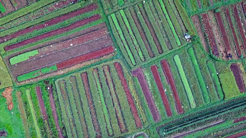
Land cover and land use mapping
Land cover maps classify regions into categories such as forest, agriculture, water, and urban areas. Land use maps describe how humans utilize land, offering insights into zoning, development, and resource allocation.
Transportation and network mapping
Transportation maps illustrate roads, railways, shipping routes, and mobility patterns. These maps are central to optimizing supply chains and planning urban transportation networks.
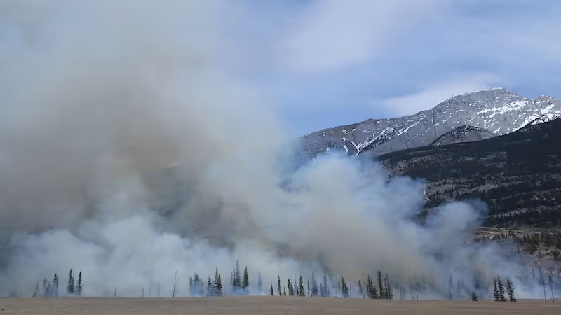
Environmental and hazard mapping
Environmental maps track environmental risks such as fires, floods, pollution, and ecological degradation. They help environmental agencies assess vulnerabilities and plan protective measures.
Each type of mapping requires specific datasets, analytical methods, and visualization approaches suited to the target domain.
Tools and Platforms Used in Geospatial Mapping
GIS software
Popular GIS tools include QGIS, ArcGIS, GRASS GIS, and GeoDa. These tools enable spatial data processing, analysis, and visualization. They offer advanced geostatistical modules and workflows for professional mapping.
Remote sensing platforms
Remote sensing platforms offer access to satellite imagery and pre processed geospatial layers. Examples include Sentinel Hub, Google Earth Engine, and NASA Worldview. These platforms allow large scale analysis using cloud infrastructure.
Database and storage systems
Spatial databases such as PostGIS, BigQuery GIS, and spatial extensions for PostgreSQL enable efficient storage and querying of large geospatial datasets. They handle spatial joins, indexing, and advanced geospatial functions.
Cloud based geospatial tools
Cloud tools streamline geospatial workflows and support scalable processing of massive imagery archives. Research groups and enterprises increasingly use cloud based mapping environments for long term spatial analysis.
External validation from the Open Geospatial Consortium (OGC) highlights how standards and tools within the geospatial ecosystem ensure interoperability across platforms and datasets.
Geospatial Data Types
Vector data
Vector data represents features as points, lines, and polygons. Examples include city boundaries, roads, buildings, and water bodies. Vector data is highly precise and suitable for mapping infrastructure and geographical boundaries.
Raster data
Raster data consists of grids of pixels. Satellite imagery, elevation models, temperature maps, and precipitation layers all fall into this category. Raster data is essential for environmental monitoring and remote sensing analysis.
Point clouds
LiDAR and photogrammetry generate point clouds that represent detailed 3D structures. These datasets support digital elevation models, urban reconstruction, and infrastructure mapping.
Tabular data with spatial attributes
Census tables and socioeconomic datasets may include coordinates or administrative boundaries. When integrated into GIS, they gain spatial context and enable powerful regional analysis.
Geospatial mapping relies on blending these data types to produce complete and accurate representations of Earth.
Geospatial Mapping Workflows
Data harmonization
Before analysis, all datasets must use compatible projections, coordinate systems, and resolutions. Harmonization ensures accurate spatial alignment and avoids errors caused by mismatched geographies.
Multi layer integration
Analysts overlay multiple layers such as elevation, vegetation, roads, and population. This creates complex spatial models that reveal interactions between human and natural systems.
Spatial statistics and modeling
Geostatistical tools help quantify spatial relationships, detect clusters, and predict trends. Spatial regression and interpolation provide deeper insights into geographic phenomena.
Map production
After analysis, cartographers create visual maps that communicate findings effectively. Good map design emphasizes clarity, color balance, and contextual annotations.
Mapping workflows require a careful blend of technical skill, domain expertise, and spatial reasoning.
Applications of Geospatial Mapping
Environmental management
Conservation groups use geospatial mapping to monitor protected areas, track habitat loss, and evaluate restoration programs. Mapping helps quantify environmental change and guide policy decisions.
Agriculture and food systems
Geospatial maps reveal crop conditions, soil moisture levels, and irrigation needs. Farmers improve crop yields by combining satellite data with field measurements.
Public health and epidemiology
Health agencies use geospatial mapping to track disease spread, identify at risk populations, and manage medical resource allocation. Mapping improves the precision of health interventions and planning.
Urban development
City planners rely on geospatial analysis to map population density, transportation networks, and land values. This informs zoning decisions and long term urban growth strategies.
Energy and utilities
Energy companies use spatial mapping to analyze renewable energy potential, assess grid vulnerabilities, and plan infrastructure deployment. Geospatial insights help optimize power distribution and maintenance planning.
Mapping therefore supports decision making in nearly every sector that relies on geographic context.
Challenges in Geospatial Mapping
Data heterogeneity
Geospatial data comes from multiple sources with different formats, resolutions, and coordinate systems. Harmonizing these datasets is difficult and requires careful technical workflows.
Cloud cover in satellite imagery
Clouds obscure significant portions of optical satellite data. Analysts must use cloud masking techniques or rely on alternative sensors such as radar.
Volume and scale
High resolution global datasets are extremely large. Processing and storing these datasets demands powerful infrastructure and optimized data pipelines.
Privacy and security
Certain geospatial data contains sensitive information. Organizations must follow strict data governance practices to protect user privacy and comply with local regulations.
Interpretation complexity
Spatial patterns can be complex and sometimes ambiguous. Accurate interpretation requires both technical expertise and domain knowledge.
These challenges highlight why geospatial expertise remains essential, even as tools become more automated.
The Future of Geospatial Mapping
AI enhanced mapping
AI systems will automate feature extraction, segmentation, and pattern detection. This will reduce manual work and accelerate large scale analysis.
Fusion of multiple data sources
Future mapping systems will integrate satellite imagery, meteorological data, demographic indicators, and IoT sensors into unified models. This creates richer and more accurate geographic intelligence.
Real time spatial analysis
Advances in edge computing and cloud infrastructure will enable near real time geospatial processing. This benefits disaster response, logistics, and security applications.
3D and 4D mapping
Mapping is expanding from 2D to 3D, and soon to 4D using temporal data. These models will capture how cities and landscapes evolve over time.
Global scale environmental monitoring
Planet scale monitoring systems will track climate variables, ecological changes, and natural hazards continuously. This will support sustainability initiatives and scientific research.
The future of geospatial mapping lies in automated analysis, spatial modeling, and integrated ecosystems of data sources.
Conclusion
Geospatial mapping is a foundational discipline that transforms raw spatial data into actionable insights for governments, industries, researchers, and communities. By combining GIS, remote sensing, AI, spatial databases, and visualization tools, geospatial mapping provides a powerful framework for understanding Earth’s surface, monitoring change, and guiding strategic decisions. As the volume of geospatial data continues to grow, organizations that invest in robust mapping workflows and advanced analytical methods will be well positioned to leverage spatial intelligence for long term impact.