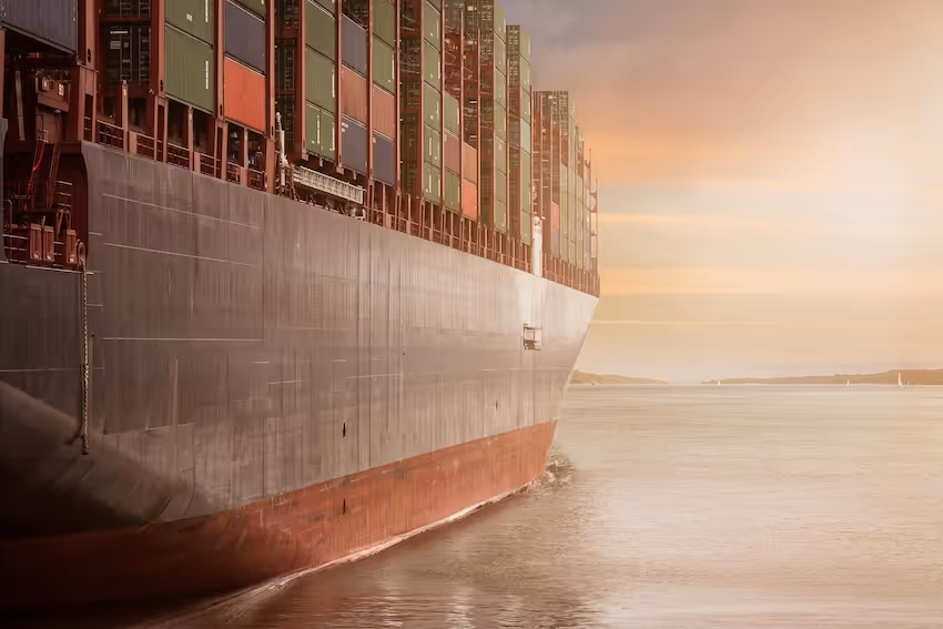
Understanding SAR for Ship Detection
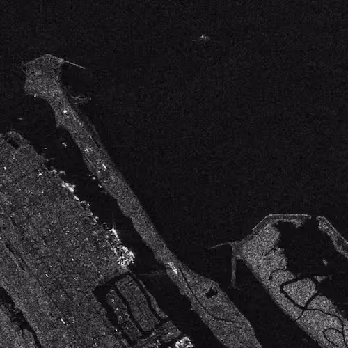
Synthetic Aperture Radar, commonly known as SAR, captures detailed surface information using microwave signals rather than visible light. This capability allows SAR satellites to penetrate clouds, operate at night, and generate consistent images regardless of weather. These characteristics make SAR an ideal source for ship detection, especially in regions with persistent cloud cover or challenging atmospheric conditions. Missions such as ESA’s Sentinel-1 provide high-resolution SAR data that supports a wide range of maritime monitoring tasks. Annotators use this imagery to label vessels, wakes, and contextual regions, creating datasets from which detection models learn to identify ships under diverse real-world conditions.
For maritime SAR datasets, DataVLab’s geospatial data annotation services can structure vessel, wake, and sea-state labels across sensor conditions.
Why SAR Is Essential for Maritime Surveillance
Ocean environments present unique challenges for visual imagery, including cloud obscuration, glare, and low illumination. SAR overcomes these limitations by capturing structural and textural information rather than color. Ships appear as bright, high-contrast targets against darker sea surfaces, making them more distinguishable in radar imagery. Because SAR can operate in all lighting and weather conditions, it ensures continuous monitoring, which is crucial for applications such as navigation safety, anti-piracy operations, and coastal security. This reliability enhances situational awareness across maritime domains.
The Role of SAR Ship Detection Datasets
SAR ship detection datasets contain radar images annotated with vessel positions, sizes, and classifications. Annotators draw bounding boxes or segmentation masks around detected vessels and note environmental conditions that influence detectability. These datasets serve as the training and evaluation material for ship detection models. They teach models to recognize ship signatures, differentiate vessels from waves, and manage uncommon scenarios such as clustered ships or near-shore reflections. The quality and diversity of these datasets directly determine model reliability.
What a SAR Ship Detection Dataset Includes
SAR ship detection datasets contain a combination of raw radar imagery, contextual metadata, and structured annotations. Annotators label vessels across multiple sea states, geographic regions, and operational conditions. They also identify background elements that can produce false positives, such as sharp wave patterns or coastal features. The goal is to ensure the model learns the full range of visual variability present in maritime environments.
Annotated Vessel Positions
Annotators place bounding boxes around each ship visible in the SAR image. These boxes capture the vessel’s approximate dimensions and location within the scene. Because SAR imagery often includes spatial distortions, annotation guidelines must specify how to treat elongated wakes or blurred reflections. Consistent bounding box placement ensures that the model learns proper spatial cues.
Environmental Metadata
Datasets often include metadata describing wind speed, sea state, wave height, or the satellite’s acquisition mode. These factors influence image appearance and vessel visibility. Annotating environmental context helps models adapt to conditions where ship detection becomes more difficult. The NOAA Geoportal provides environmental datasets that can complement SAR imagery with contextual oceanographic information.
Challenges in SAR Ship Detection
SAR imagery introduces specific challenges that must be addressed during dataset construction. Radar signals interact with moving seawater in complex ways, producing texture variations that can mimic ship signatures. Additionally, vessel wakes, near-shore reflections, and overlapping ships may complicate the labeling process. These complexities require annotators to follow strict guidelines and reference materials to maintain label consistency.
Distinguishing Vessels From Radar Artifacts
SAR images contain artifacts such as speckle noise and surface backscatter, which can resemble small ships. Annotators must recognize the difference between actual vessels and radar noise patterns. Training datasets must incorporate examples of both to help detection models avoid false alarms.
Handling Varying Ship Sizes
Ships range from small fishing boats to large cargo vessels, each producing distinct radar signatures. Models must learn to detect ships across this wide spectrum of scales. Annotators create labels that accurately capture these differences while avoiding under-segmentation or over-segmentation. Including diverse vessel types helps models handle real-world maritime traffic patterns.
Building Annotation Guidelines
High-quality SAR ship detection datasets depend on clear, structured annotation guidelines. These guidelines define how annotators identify ships, how to treat ambiguous regions, and how to document environmental artifacts. Guidelines also set rules for dealing with partially visible ships or scenes where vessels overlap.
Defining Label Categories
Label categories may include various ship types, such as fishing vessels, cargo ships, passenger vessels, and small boats. Annotators may also label non-ship objects that appear in the image, enabling multi-class detection models. Defining categories precisely helps reduce confusion and improves annotation accuracy across large teams.
Ensuring Annotation Accuracy
Annotation teams use quality assurance processes to verify label precision and evaluate consistency across contributors. Reviewers check that bounding boxes align with vessel shapes and that environmental artifacts are handled correctly. Multi-stage QA processes help refine the dataset and minimize noise that could degrade model performance.
How Ship Detection Models Learn From SAR Datasets
Ship detection models use annotated SAR datasets to learn spatial patterns associated with vessels. During training, the model analyzes vessel shapes, brightness contrasts, and wake structures. It then builds feature representations that allow it to detect ships in new images. The structure of SAR imagery ensures that models learn robust features that remain stable across weather conditions and times of day.
Feature Learning in Radar Imagery
Radar imagery emphasizes differences in surface roughness, which helps models detect ships through their backscatter patterns. Models learn to recognize bright, compact signatures surrounded by darker surroundings. They also learn to differentiate vessel wakes from the ships themselves. These learned features support accurate detection across diverse maritime conditions.
Output Formats
Models may produce bounding boxes, segmentation masks, or confidence maps indicating vessel probability. Bounding boxes are commonly used for basic ship detection, while segmentation masks support more detailed analysis such as vessel shape estimation. Regardless of format, output quality depends heavily on the granularity of the training annotations.
Evaluating Ship Detection Models
Evaluating ship detection models requires test sets that represent the full variability of real-world maritime conditions. Performance must be assessed on images containing small vessels, cluttered near-shore environments, and rough sea states. Precision, recall, and intersection-over-union metrics help quantify detection quality.
Cross-Domain Evaluation
Ship detection models must perform consistently across different geographic regions and environmental conditions. Datasets that include samples from multiple coasts, open ocean areas, and shipping lanes help ensure generalizability. The U.S. Marine Cadastre’s AIS datasets, which provide vessel tracking information, can be used to complement imagery evaluations and validate model detections.
Avoiding Model Bias
Bias can occur when datasets overrepresent certain vessel types or environmental conditions. Balanced sampling strategies help mitigate this issue, ensuring that models receive adequate exposure to varied scenes. Monitoring performance across ship categories and regions helps identify potential biases.

Applications of SAR Ship Detection Datasets
SAR ship detection datasets support a wide range of maritime applications. Governments, researchers, and private organizations use these datasets to enhance situational awareness and monitor vessel activity across vast regions.
Maritime Safety and Navigation
Detection models help identify vessel positions, reducing collision risks and supporting navigation systems. In busy maritime corridors, automated detection improves vessel tracking and ensures compliance with safety protocols. Integration with coastal monitoring tools enhances risk anticipation capabilities.
Illegal Fishing and Maritime Security
SAR detection supports monitoring efforts against illegal, unreported, and unregulated fishing. Because SAR operates at night and in poor visibility, it allows agencies to track vessels that may otherwise remain undetected. Remote sensing capabilities such as those researched by the U.S. Naval Research Laboratory demonstrate how advanced radar analysis supports maritime security operations.
Future Advancements in SAR Ship Detection
The future of SAR ship detection involves improvements in sensor resolution, adaptive learning, and multimodal data integration. As SAR technologies progress, models will be able to detect smaller vessels and identify ships with greater accuracy.
Higher-Resolution Radar Sensors
Next-generation radar missions promise enhanced spatial resolution, improving the visibility of small fishing vessels and near-shore craft. These advancements will require new annotation methodologies that capture finer vessel details.
Multimodal Detection Systems
Combining SAR with optical imagery, AIS data, or LiDAR will produce richer datasets capable of supporting more advanced detection tasks. Such systems will help identify vessel types, estimate cargo loads, and track behavior patterns. They will also support predictive analytics for maritime risk assessment.
If You Are Developing Maritime Surveillance Models
High-quality SAR ship detection datasets are essential for building accurate and reliable maritime monitoring systems. If you need support creating radar imagery datasets, designing annotation guidelines, or improving model performance, the DataVLab team can help you develop structured datasets tailored to maritime environments. Share your goals, and we can explore how to strengthen your detection workflows with robust, well-annotated training data.