Understanding Oil Spill Detection
Oil spill detection relies on computer vision models that analyze satellite and aerial imagery to identify the presence of oil on ocean surfaces, usually caused by transportation ships. These models learn from curated datasets containing annotated examples of oil slicks observed under a variety of atmospheric and oceanic conditions. The environmental impact of oil spills makes rapid detection essential, as early identification helps reduce ecological damage and enables more targeted response strategies. Satellite platforms operated by institutions such as NASA provide imagery that documents large-scale ocean phenomena, giving researchers access to diverse visual examples of surface discoloration and hydrocarbon diffusion patterns. These images form valuable inputs for annotators who label oil spill areas for downstream model training.
Importance of Detecting Oil on the Ocean Surface
Marine ecosystems are sensitive to chemical pollution, and oil spills disrupt food webs, harm wildlife, and introduce long-term contamination into coastal regions. Detection systems assist response agencies by monitoring large marine areas more efficiently than manual observation approaches. They allow organizations to track spill evolution, identify affected regions, and prioritize cleanup operations. Because oceanic conditions change rapidly due to wind, waves, and currents, relying solely on human inspection is insufficient. Computer vision helps produce timely, repeatable insights that support environmental protection efforts.
Role of Satellite and Aerial Imagery
Satellite and aerial platforms capture high-resolution images that reveal oil dispersion patterns across vast ocean surfaces. The European Space Agency’s Earth observation missions provide consistent imagery that researchers use to study environmental conditions and detect anomalies in ocean color or texture. Annotators analyze these images to segment oil slick shapes, define boundaries, and identify regions where hydrocarbons have dispersed. These annotations become the ground truth for training data, ensuring that the detection model learns to differentiate oil from natural phenomena such as algal blooms or wave patterns.
What an Oil Spill Detection Dataset Contains
An oil spill detection dataset consists of labeled imagery representing diverse ocean conditions, oil spill shapes, and environmental contexts. These datasets include visual samples captured at different times of day, varying angles, and multiple spectral bands when available. Annotators mark oil slick boundaries, transitions from dense to thin surface layers, and areas where the spill has fragmented. The consistency of these annotations is essential, as detection models depend on accurate labels to learn the correct visual signatures.
Annotated Slick Boundaries
Oil slicks vary in appearance depending on thickness, sun angle, and underlying wave motion. Annotators outline precise boundaries using polygonal or contour-based annotation methods. These boundaries help models learn how oil interfaces with surrounding water under different lighting conditions. Since spills often exhibit diffuse edges, annotation guidelines must specify how to label transitional areas to reduce ambiguity and maintain labeling consistency across the dataset.
Environmental Context Labels
Beyond the slick boundaries, annotators may label contextual elements that influence detection accuracy. These elements include cloud cover, surface reflections, or areas with strong sun glint. Some datasets incorporate multiple annotation classes to differentiate between thick, emulsified, or sheen-based oil layers. Such differentiation helps models adapt to varied spill morphologies and improves segmentation performance.
Challenges in Oil Spill Detection
Identifying oil in satellite imagery is challenging due to complex environmental variability. Evening shadows, cloud formations, and surface roughness can produce patterns that appear similar to oil. Atmospheric haze, wave streaks, and biological activity contribute additional noise that models must learn to ignore. NOAA’s educational resources highlight how environmental conditions affect oil appearance and why accurate interpretation requires specialized knowledge. These complexities emphasize the importance of annotated datasets that capture a broad range of difficult scenarios.
Distinguishing Oil from Natural Phenomena
Algal blooms, sediment plumes, and foam lines may resemble oil in sensor data. Annotators must accurately differentiate these phenomena to prevent false positives in the dataset. Poor annotation quality introduces errors that cascade into model predictions, reducing reliability in operational environments. Ensuring that annotators have access to clear guidelines and reference materials improves labeling accuracy and helps models generalize to unfamiliar ocean conditions.
Dealing With Sensor Limitations
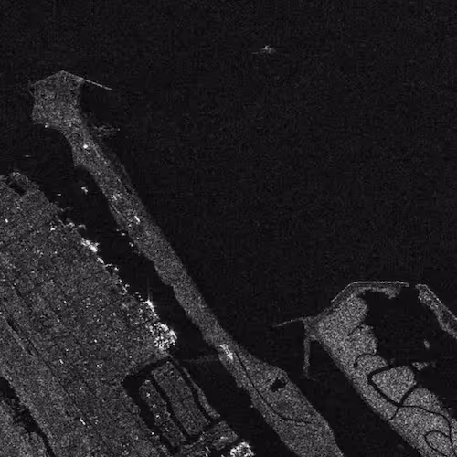
Different satellites capture data in varying spectral bands, and some sensors are more suitable than others for detecting oil. Optical sensors may struggle with cloud cover or high turbidity, while radar sensors can penetrate clouds but may produce artifacts that challenge detection models. ESA’s Sentinel-1 radar mission, for example, provides SAR imagery that detects oil by measuring surface roughness changes. Annotators must understand the unique characteristics of each sensor to label data consistently and correctly.
Dataset Diversity and Environmental Representation
A strong oil spill detection dataset includes samples captured across multiple geographic regions, seasons, and sensor types. Diversity ensures that models learn the full variability of ocean dynamics. Environmental factors such as currents, wind direction, and wave height influence spill appearance. Datasets must incorporate examples of these variations to reduce the risk of model bias and improve robustness.
Multi-Sensor Integration
Combining optical and radar imagery can enhance detection accuracy by providing complementary information. Optical images reveal color variations, while radar highlights texture differences. Annotating both types of imagery expands the dataset’s representational power. Models trained on such multimodal samples can operate effectively under a wider range of environmental conditions.
Sampling Across Spill Life Cycles
Oil spills evolve quickly due to evaporation, emulsification, and dispersion. Datasets must capture early-stage slicks, mid-stage emulsified patterns, and late-stage residual films. Annotators segment each stage carefully so models learn how visual characteristics shift over time. This helps detection systems remain accurate across extended monitoring periods.
Building Annotation Guidelines for Oil Spill Datasets
Well-defined annotation guidelines ensure consistency across large teams and multi-phase dataset creation cycles. These guidelines explain how to treat diffuse edges, how to differentiate oil from environmental noise, and how to handle ambiguous regions where multiple interpretations are possible.
Defining Annotation Categories
Categories may include thick oil, emulsified oil, sheen, natural lookalikes, or uncertain regions. Clear definitions help annotators apply labels uniformly and reduce confusion across the dataset. Guidelines may include example images that illustrate each category under several environmental conditions.
Ensuring Quality and Consistency
Quality assurance teams review annotations to confirm that boundaries align with visual cues and adhere to project rules. These reviews catch inconsistencies and help refine annotation strategies. Continuous QA ensures that dataset quality remains stable as new samples are added.
How Detection Models Learn From Oil Spill Datasets
Oil spill detection models use annotated datasets to learn the visual characteristics of hydrocarbon contamination. Deep learning architectures analyze labeled regions and internalize patterns that distinguish oil from water. During training, the model evaluates examples and adjusts weights until it minimizes prediction error.
Feature Learning in Ocean Imagery
Models learn features such as reflectance patterns, surface texture changes, and spectral signatures associated with oil. These features vary significantly across environmental conditions, which is why training data must reflect a wide range of scenarios. The internal structure of the model captures these features at multiple abstraction levels, from simple edge variations to complex spatial distributions.
Output Interpretation
Depending on design, models may produce segmentation masks, bounding boxes, or classification tags. Segmentation masks are common for oil spill detection because they provide pixel-level boundaries that align with real spill shapes. This granularity helps environmental agencies generate accurate area estimates and supports prediction tasks such as dispersion modeling.
Evaluating Oil Spill Detection Models
Model evaluation determines whether the system can reliably detect oil under real-world conditions. Evaluation metrics consider precision, recall, and segmentation accuracy. The dataset must be split into training, validation, and testing sets to ensure fair assessment.
Testing Under Environmental Variability
Models must be evaluated across diverse conditions, including cloudy skies, low sun angles, and rough seas. Testing across varied scenarios helps developers identify weaknesses and refine training data accordingly. ScienceDirect’s domain literature shows how environmental variability significantly influences detection outcomes and highlights the need for strong evaluation protocols.
Continual Model Improvement
As new spills occur and more imagery becomes available, datasets must be updated. Continual improvement cycles allow models to adapt to new conditions, sensors, and spill patterns. This approach ensures sustained relevance in operational environments and minimizes performance drift.
Applications of Oil Spill Detection Datasets
Oil spill detection datasets enable a wide range of applications across environmental monitoring, maritime safety, and scientific research. These datasets empower agencies and organizations to detect anomalies quickly and respond to environmental threats with greater clarity.
Environmental Protection and Compliance
Regulatory bodies use detection systems to monitor sensitive marine regions and enforce compliance with environmental safeguards. Automated detection helps identify illegal discharges, evaluate spill extent, and track repeat offenders. The system provides high-resolution evidence needed for enforcement actions.
Operational Monitoring and Emergency Response
When spills occur, rapid assessment is essential. Computer vision models trained on annotated datasets allow agencies to detect spill boundaries quickly and deploy resources more effectively. Automated monitoring reduces the time between spill occurrence and response activation.

Future Directions in Oil Spill Detection
Advances in machine learning, remote sensing, and oceanographic modeling are shaping the next generation of oil spill detection workflows. Improved sensors, adaptive learning systems, and enhanced annotation methodologies will further strengthen dataset quality.
Higher-Resolution Sensors
New satellite platforms promise improved resolution, enabling more detailed detection of small spills and minor hydrocarbon leaks. With clearer imagery, annotation teams can label boundaries with greater precision, improving model fidelity.
Multimodal and Predictive Models
Integrating oceanographic data, vessel tracking information, and meteorological inputs will enable models to predict spill trajectories and identify likely sources. These multimodal workflows will require expanded datasets that include additional contextual features.
If You Are Developing Marine Monitoring Systems
Building reliable oil spill detection models requires diverse datasets, precise annotation workflows, and careful evaluation across real-world conditions. If you need support creating or refining large-scale environmental monitoring datasets, the DataVLab team can help design annotation strategies that strengthen model performance and accelerate deployment timelines. Share your objectives, and we can explore how best to support your marine AI initiatives.