Why Crop Classification Matters in Agriculture
Crop classification is a foundational capability in digital agriculture because it enables automated mapping of crop types and field conditions across large geographic areas. Farmers, agronomists and research institutions use classification models to monitor planting patterns, estimate yield, track crop rotations and guide fertilization and irrigation planning. Studies from the European Space Agency show how field level crop type classification is used in Earth observation systems to support policy, food security and sustainability initiatives. As agriculture becomes more data driven, crop classification is emerging as a critical layer in decision making pipelines. Robust annotations are required for AI models to interpret the complex visual signals present in agricultural landscapes.
Understanding Crop Classification in Machine Learning
Crop classification models rely on annotated datasets that label crops at pixel, patch or field level. These labels teach machine learning systems how different crop types appear under varying conditions. When datasets include enough diversity across locations, seasons and phenological stages, models can generalize well to new fields. Research from the USDA Agricultural Research Service highlights how annotated field imagery supports crop condition forecasting and large scale monitoring programs. Without structured annotation, AI systems struggle to differentiate crops that appear visually similar or vary widely due to environmental influences.
Image Types Used for Crop Classification
Crop classification datasets may include satellite imagery, drone data or close range field images depending on the intended use case. Satellite images provide broad coverage, making them suitable for national scale crop mapping. Drone images capture more detailed crop structures, allowing fine grained recognition of plant characteristics. Ground level images help models understand texture, leaf patterns and canopy density. Sentinel Hub’s documentation illustrates how multispectral satellite data enhances classification by capturing signals linked to plant health and structure. Combining image types creates a more comprehensive dataset that strengthens model performance.
What Models Learn From Annotated Crop Data
Well annotated datasets allow models to learn patterns related to leaf color, growth uniformity, planting geometry and canopy texture. These patterns differ among species such as wheat, maize, soy or rice, enabling classification systems to assign accurate labels across fields. Models also learn contextual cues like the arrangement of crop rows or the presence of bare soil between plants. With enough examples, the system builds an internal representation of each crop type that remains reliable under varied real world conditions. The clarity of annotation classes directly influences the quality of the learned features.
Defining Categories for Crop Classification
Defining annotation categories is one of the most important steps in dataset preparation. Categories may include high level crop types, specific varieties or even sub categories related to growth stages. Clear definitions ensure that annotators remain consistent when labeling images. The International Maize and Wheat Improvement Center provides extensive agricultural taxonomy resources that can guide category standardization. Ambiguous or overlapping categories often lead to inconsistent labeling and lower model performance. Establishing a clear taxonomy from the beginning avoids misinterpretation later in the project.
High Level Crop Type Categories
Most crop classification datasets begin with simple categories such as wheat, maize, rice, soy or barley. These high level labels enable broad scale mapping across regions and seasons. In some cases, categories may include fallow land or mixed vegetation when fields contain multiple plant types. Developers must ensure that each crop type appears frequently enough to support reliable model training. If certain crops have fewer examples, targeted data collection may be necessary.
Variety Level and Fine Grained Classes
More advanced datasets may include subclass labels to differentiate crop varieties or hybrids. These fine grained categories are useful for agricultural research, seed breeding and field trials. Annotators need detailed examples to distinguish varieties that may look similar at certain growth stages. High resolution images and expert review are essential when working with fine grained classes. Clear annotation instructions prevent confusion among varieties that have subtle visual differences.
Growth Stages and Phenology
Some datasets incorporate phenological stages such as emergence, tillering, flowering or maturity. These categories support growth monitoring and yield estimation models. Incorporating growth stage labels requires consistent timing in data collection and annotation. Developers may rely on agronomists to define the criteria for each stage. When these phases are represented accurately in the dataset, models can predict crop development more effectively.
Creating Image Datasets for Crop Classification
Dataset creation begins with acquiring images that represent the diversity of the target environment. Crop appearance changes with climate, soil type and planting practices. Therefore, datasets must capture these variations to prevent model overfitting. Field level imagery from regions with different weather patterns ensures robust learning. The University of Minnesota’s agricultural imagery research illustrates how geographic diversity improves classification accuracy in large scale systems. Developers should plan data collection strategies that cover all relevant environmental scenarios.
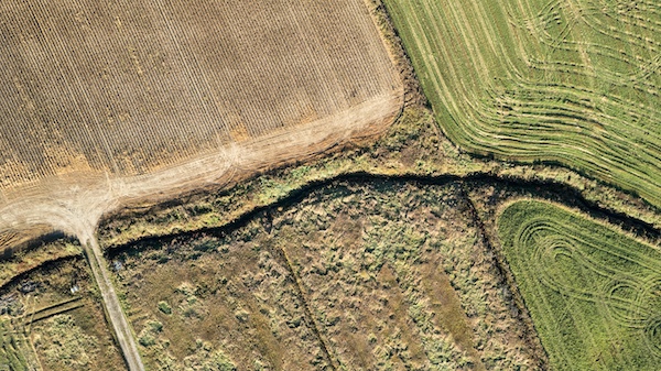
Satellite and Aerial Data Collection
Satellite imagery offers extensive spatial coverage, allowing datasets to include hundreds of thousands of hectares at once. Platforms such as Sentinel, Landsat and commercial satellites provide multispectral, high resolution data for crop classification tasks. Drone flights supplement this data by capturing finer details that satellites may miss. When combining both sources, developers gain a multi scale dataset that supports precise and scalable classification models. Ensuring temporal alignment across imagery is crucial for maintaining consistency.
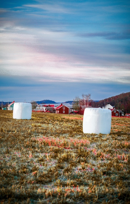
Ground Level Imagery and Field Photography
Ground level images capture the visual nuances of crops at close range. These images help models learn texture, density and leaf structure characteristics that may not be visible from above. Field photography also aids in understanding environmental context, such as soil moisture or weed presence. Developers may collect these images using handheld cameras, fixed sensors or tractor mounted systems. Ground level imagery strengthens the dataset by adding rich information that complements aerial data.
Image Preprocessing and Preparation
Raw images often require preprocessing to correct distortions, standardize formats or align spectral bands. Satellite imagery may need atmospheric correction or geospatial alignment. Drone images might require normalization to account for flight altitude variations. Ground images may need cropping, resizing or exposure balancing. Preprocessing ensures that the dataset remains consistent, making annotation easier and model training more effective. Clean images also reduce noise that may confuse classification algorithms.
Annotation Methods for Crop Classification Datasets
Annotation methods vary depending on the granularity required for the classification task. Pixel level segmentation provides the highest detail, while patch level classification or bounding boxes may suffice for broader applications. The method chosen affects annotation time, dataset size and model architecture. Developers must select a method that aligns with project goals and resource constraints. Clear guidelines and annotation tools help ensure consistency across teams.
Field Level Polygon Annotation
Polygon annotation is commonly used for field level crop classification. Annotators outline field boundaries and assign crop types to each polygon. This method works well with satellite and drone imagery where fields appear clearly defined. It enables models to classify entire agricultural parcels rather than individual plants. Annotators must follow strict rules to ensure polygons align with real field boundaries. Consistency in boundary placement is essential for downstream geospatial analysis.
Patch Based Annotation
Patch based annotation divides imagery into fixed size segments, each labeled with a crop type. This approach reduces annotation complexity because annotators do not need to draw boundaries. Patch labels work well for machine learning models that analyze uniform grid inputs. However, patches may contain mixed vegetation, requiring careful guidelines on how to label ambiguous regions. Developers often define threshold rules, such as labeling based on the dominant crop type.
Pixel Level Annotation for Fine Detail
Pixel level segmentation provides the most detailed annotation by classifying each pixel in the image. This method is essential when precise plant structure information is required. It supports fine grained classification and advanced phenotyping tasks. However, pixel level annotation is time consuming and requires specialized tools. Quality control becomes critical due to the complexity of the labeling process. This approach is typically reserved for high value datasets.
Ensuring Annotation Consistency and Quality
Consistency across annotators is crucial for building reliable datasets. Comprehensive guidelines reduce errors and ensure uniform labeling across thousands of images. Multi stage quality control processes help maintain accuracy and catch mistakes early. Expert review further strengthens dataset reliability, especially when dealing with subtle crop type differences. Quality control must remain a continuous process throughout dataset construction.
Annotation Guidelines and Training
Annotators must understand crop types, field boundaries and labeling rules before beginning work. Training sessions and reference examples help clarify expectations. Guidelines should explain edge cases, such as partially visible fields or mixed crop areas. Developers may provide visual aids showing correct and incorrect labeling examples. Well informed annotators produce consistent, high quality labels that improve model performance.
Multi Stage Quality Review
Quality review typically involves multiple layers of checking. First level reviewers ensure that annotations follow instructions and match category definitions. Second level reviewers conduct more detailed checks for accuracy, boundary precision or pixel consistency. Experts may provide additional feedback when necessary. This structured review process minimizes errors and ensures a high confidence dataset. Automated validation tools may also assist in detecting anomalies.
Balancing Class Distribution
Crop datasets often contain imbalances because certain crops dominate specific regions or seasons. Imbalanced classes cause models to overfit to majority classes while underperforming on minority ones. Developers must ensure that minority classes receive enough representation through targeted data collection or augmentation. Balanced datasets lead to more equitable model performance across categories.
Challenges in Crop Classification Annotation
Crop classification presents unique challenges due to seasonal changes, geographic variability and field occlusions. Satellite and drone imagery may suffer from cloud cover, shadows or inconsistent lighting. Ground imagery may include weeds, debris or overlapping plants. These complexities require careful annotation and dataset design. Developers must anticipate these challenges and address them through robust data collection and quality control practices.
Seasonal Variability and Phenological Shifts
Crops change appearance significantly throughout their growth cycle. Early stage plants may look very different from mature crops. Seasonal variability can cause misclassification if datasets lack temporal diversity. Developers should collect imagery at multiple stages to ensure that models generalize well. Annotating growth stages separately improves model understanding and reduces seasonal bias.
Environmental and Geographic Differences
Geographic differences impact plant appearance, soil color and field structure. A crop grown in one region may look different from the same crop grown elsewhere due to climate or farming practices. Without geographic diversity, models may overfit to specific environments. Collecting data across multiple regions ensures a more robust dataset that performs well globally. Developers must also consider different irrigation methods or planting densities when designing datasets.
Occlusions and Mixed Vegetation
Fields often contain weeds, overlapping rows or mixed vegetation. These elements complicate annotation because they obscure important features. Annotators must distinguish between target crops and background elements. Mixed areas may require special labeling protocols to avoid confusion. High resolution imagery and clear guidelines help reduce errors caused by occlusions.

Building Scalable Crop Classification Datasets
Scaling annotation workflows requires efficient tools, streamlined guidelines and experienced teams. Large agricultural projects often involve millions of pixels or thousands of polygons. Scalable systems must support batch processing, pre labeling and automated suggestions. Annotation teams must maintain consistency even as datasets grow in size. Effective management ensures that large datasets meet quality standards without excessive delays.
Automation and Pre Labeling Techniques
Automated pre labeling tools accelerate annotation by providing initial predictions. Annotators then correct these predictions rather than labeling from scratch. Pre labeling reduces workload and improves throughput. It also helps standardize annotations across large teams. Developers must validate pre labels thoroughly to avoid propagating errors.
Expert Review and Knowledge Integration
Expert agronomists contribute valuable insights that improve dataset accuracy. Their knowledge helps refine category definitions, resolve edge cases and correct difficult samples. Integrating expert review into the annotation pipeline ensures scientific accuracy. This is especially important for complex crop types or fine grained classes.
Dataset Versioning and Maintenance
Long term projects require version control to track dataset updates. Developers must document changes in categories, annotation rules or image sources. Versioning helps maintain consistency when retraining models or expanding datasets. Proper documentation ensures continuity even when team members change.
How Annotated Datasets Power Crop Classification Models
Accurate annotations provide the foundation for reliable crop classification models. Without structured data, even advanced algorithms cannot understand agricultural imagery. High quality labels enable models to differentiate crop types, detect anomalies and support precision farming decisions. They also help models scale across regions, seasons and image modalities. Well designed datasets have long lasting value in agricultural research and commercial applications.
Model Training and Evaluation
Annotated datasets are split into training, validation and test sets to ensure fair evaluation. Models learn from the training set and adjust parameters based on validation feedback. The test set provides a final performance measure. Developers must ensure that the test set represents the full diversity of the dataset. Proper dataset splitting prevents data leakage and ensures reliable benchmarking.
Deployment and Field Performance
Models deployed in the field must handle unpredictable conditions. Robust datasets prepare models for variability in lighting, weather and plant appearance. Developers must monitor performance continuously and collect new data when accuracy declines. Deployments benefit from ongoing dataset expansion and retraining. Real world feedback helps refine both annotation and model design.
Integration with Precision Agriculture Systems
Crop classification models integrate with mapping tools, farm management platforms and decision support systems. These integrations allow farmers to visualize crop distributions, monitor trends and plan operations. Accurate classification enhances irrigation planning, fertilizer application and yield estimation. As agriculture becomes more automated, crop classification datasets will power increasingly sophisticated systems.
Supporting Your Agricultural AI Projects
If you are building crop classification models or designing large scale agricultural datasets, we can support you with expert annotation workflows tailored to field level imagery, satellite data and complex crop taxonomies. Our teams specialize in scalable dataset creation, quality control and category standardization to help your models perform reliably in real environments. If you would like help structuring or annotating your next agricultural dataset, feel free to reach out.