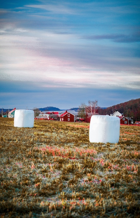
Why Satellite Imagery is a Game-Changer for Agriculture 🌍
The agricultural sector is undergoing a seismic shift powered by data—and at the core of this transformation is satellite imagery. From smallholder plots to massive industrial farms, the ability to remotely observe and analyze crop health, soil conditions, water availability, and land use patterns provides decision-makers with an unprecedented level of control.
But capturing images is only the beginning. The value lies in interpretation.
That’s where annotation comes in.
Annotation allows us to convert raw pixels into meaningful, labeled data. These labels are used to train machine learning models that can, for example:
- Detect specific crop types
- Identify areas under stress
- Track irrigation efficiency
- Predict yields
- Monitor seasonal land use changes
Using annotated satellite data, AI models can automatically analyze large swaths of land with minimal human input—driving both productivity and sustainability.
How Annotation Enhances Agricultural Mapping Accuracy 🌾
Agricultural mapping is not just about creating pretty visualizations of land. It's about extracting usable intelligence from vast image datasets. That’s why annotation is central to effective satellite-based agricultural applications.
Let’s break down how annotation enhances mapping efforts in key domains:
Crop Classification and Rotation Mapping
By labeling known crop regions in satellite imagery over multiple seasons, annotation helps train models that distinguish between wheat, corn, soy, rice, and other crops based on visual and spectral signatures. Annotated time-series data can reveal patterns of crop rotation—essential for both agronomic planning and compliance monitoring.
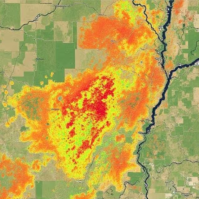
Detecting Vegetation Stress and Health
Spectral indices like NDVI (Normalized Difference Vegetation Index) are commonly used to detect crop stress. However, AI models need labeled ground-truth regions where stress was known to occur in order to accurately classify it. Annotated maps serve as validation benchmarks and training data for stress-detection algorithms.
Mapping Irrigation Infrastructure and Water Use
Annotated images of irrigation canals, drip lines, and wet/dry areas are instrumental in building models that infer irrigation patterns. These insights are crucial in arid regions where water management is a priority.
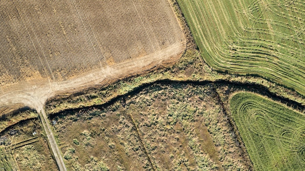
Land Use and Parcel Delineation
Drawing precise boundaries around agricultural parcels allows models to automatically detect field edges, identify encroachments, or separate cropland from forest or urban zones. These boundaries are often manually annotated from high-resolution satellite images to serve as a basis for automatic segmentation.
Yield Estimation and Forecasting
Historical satellite imagery annotated with actual yield records enables models to make predictive inferences. This helps governments, food supply chains, and farmers prepare for shortages or surpluses.
Challenges in Annotating Satellite Data for Agriculture 🛰️
While the benefits are clear, annotating satellite imagery for agriculture comes with unique challenges.
1. Resolution vs. Coverage
High-resolution imagery (e.g., from Planet Labs or Maxar) provides detailed visual information but is expensive and not always available at scale. Lower-resolution images (e.g., from Sentinel-2) are free and offer broader coverage but may lack the detail needed for accurate annotations of small plots.
Balancing resolution and scale is a constant tradeoff.
2. Seasonal Variability and Spectral Shifts
Crops look vastly different at various growth stages. A field of maize in June is visually distinct from that same field in August. Annotation projects must account for this by labeling data across different phenological stages and sensor bands.
3. Ground Truth Limitations
For accurate annotation, on-the-ground validation is often required. But field access is not always feasible, especially in conflict zones or remote areas. In such cases, experts must rely on secondary data sources like historical crop calendars, farming registries, or previous surveys.
4. Cloud Cover and Atmospheric Interference
Satellites often capture images obstructed by clouds or atmospheric haze, which distorts visibility. Annotators must either skip these sections, apply corrections, or use multi-date composites for better clarity.
5. Ambiguity in Land Use Labels
What exactly constitutes “Agriculture” isn’t always clear-cut. Fields left fallow, mixed-use plots, and agroforestry areas can confuse even experienced annotators. Standardizing class definitions and applying hierarchical labeling strategies is essential for consistency.
Real-World Applications That Make an Impact 💡
Annotation work is the behind-the-scenes engine that drives many high-impact agricultural use cases today. Let’s look at some of the most valuable implementations:
Early Warning Systems for Food Insecurity
Organizations like FAO and WFP rely on annotated satellite imagery to power AI-driven early warning systems. By monitoring vegetation cover and agricultural expansion, they predict regions at risk of food shortage months in advance.
Precision Farming Platforms
Tech companies are building precision agriculture solutions that use annotated imagery to inform farmers when to water, fertilize, or harvest. For example, John Deere Operations Center and Corteva's Granular depend on spatial AI models trained with clean, annotated satellite data.
Crop Insurance Claims Validation
Insurers use satellite images to verify damage claims during events like droughts or floods. Annotation helps delineate the impacted zones and compare before/after snapshots to automate claim verification, speeding up payouts.
Government Subsidy Auditing
Annotated images allow ministries of agriculture to monitor if declared cropland matches actual land use. This curbs fraud in subsidy disbursement and ensures funds reach the right hands.
Best Practices for Accurate Agricultural Annotations ✅
Based on years of field experience and large-scale labeling projects, here are key practices for building high-quality agricultural datasets:
- Start with a clear taxonomy: Define your crop types, land use classes, or stress levels before labeling begins. Use hierarchical taxonomies when appropriate.
- Use reference imagery and historical data: Annotators perform better with visual context from previous years or neighboring plots.
- Apply consensus labeling: Multiple annotators labeling the same image—followed by consensus or adjudication—helps reduce subjectivity and bias.
- Incorporate domain experts: Collaborate with agronomists, local officials, or GIS analysts to verify that annotations match field reality.
- Validate across seasons: Ensure your training data reflects the phenological variability of crops across the growing season.
- Avoid label leakage: Don’t use post-harvest or yield data to label imagery unless the model explicitly aims to learn from future events.
The Role of AI-Assisted Annotation 🧠
AI-assisted annotation is becoming indispensable in agricultural satellite imagery projects. With the growing volume of high-resolution imagery generated by satellites like Sentinel-2, Landsat 8, and PlanetScope, manually labeling data at scale is no longer feasible without automation.
Here’s how AI is transforming annotation workflows in agricultural mapping:
Smart Pre-Labeling: Saving Time and Energy
Many modern annotation platforms now offer smart pre-labeling, where deep learning models generate initial annotations (e.g., field boundaries, crop classes, vegetation indices) based on historical datasets or prior model runs. Annotators simply review and adjust these pre-labels instead of starting from scratch—speeding up the process by up to 70%.
This is especially useful in agricultural contexts where recurring land features (like crop rows or irrigation lines) exhibit strong visual consistency.
Human-in-the-Loop (HITL) Models: Precision with Oversight
The HITL model is gaining traction for a reason—it combines the strengths of machine learning with human judgment. When annotating satellite data, AI can detect potential field boundaries, forest encroachment, or areas of crop stress, but it’s the human expert who validates if the AI’s interpretation is contextually accurate.
For example, a model might flag a region as "fallow land" due to spectral dryness, but a human might know it’s simply post-harvest stubble. This validation step is critical in reducing false positives and ensuring label quality.
Active Learning Loops: Teaching the Model What’s Hard
In active learning systems, the AI model flags ambiguous or low-confidence samples for human review. This makes annotation more efficient by focusing expert attention on the most difficult cases—such as mixed-use parcels, irregular field boundaries, or cloud-obstructed zones.
These difficult samples often drive the biggest performance improvements when added to the training set.
AI for Annotation QA: Automated Error Detection
Another powerful application is using AI to assist in quality control. Once human annotators have completed a batch, automated scripts can scan for inconsistencies—such as overlapping polygons, label mismatches, or missing metadata. This not only increases throughput but helps maintain a high standard across large annotation teams.
Generative AI in Annotation: An Emerging Frontier
Looking forward, Generative AI is beginning to impact annotation, especially in tasks like synthetic dataset creation or context-aware labeling. Imagine generating synthetic labeled imagery of crops under rare weather conditions (like hailstorms) to augment training data where real-world samples are lacking. While early in its adoption, this technology holds promise for edge-case coverage and annotation diversity.
How to Measure the Impact of Your Annotation Project 📈
If you’re investing time and resources into labeling agricultural satellite imagery, it’s essential to evaluate outcomes. Consider these KPIs:
- Model accuracy: Has precision/recall improved since adding new annotated data?
- Coverage expansion: How much more land area can your model analyze?
- Insight granularity: Are predictions becoming more localized and actionable?
- Stakeholder adoption: Are farmers, insurers, or policy-makers using your outputs?
- Annotation throughput: Are your labeling workflows efficient and scalable?
Capturing this feedback helps continuously improve dataset quality and align your annotation strategy with end-user goals.
What’s Next in Satellite-Based Agricultural AI? 🚀
The convergence of agri-tech, remote sensing, and AI is opening doors to powerful innovations in how we manage land, food systems, and environmental resilience. The next decade will redefine not only how we farm but how we plan, protect, and sustain agricultural ecosystems.
1. Hyper-Personalized Decision Support Systems
Imagine a farmer receiving daily insights tailored to their exact 2-hectare plot—alerts like:
“🌡️ Your northeast field is under-irrigated. Consider watering today to avoid stress.”
This hyper-personalization will be powered by AI models trained on annotated satellite imagery combined with IoT, weather forecasts, and soil data. Annotated maps will provide the spatial foundation for such insights, with context-aware models adjusting recommendations based on historical behavior and regional patterns.
2. AI + Weather: Predictive Resilience for Climate Risks
By merging annotated land cover data with climate models, AI can forecast climate stress scenarios—like drought hotspots or flood-prone zones—with increasing precision. Annotated satellite maps help calibrate these models by identifying vulnerable croplands, assessing land degradation trends, or visualizing natural buffer zones like wetlands and tree belts.
The result? Better disaster preparedness and climate adaptation strategies for both farmers and governments.
3. Cross-Sensor Fusion: Combining Radar, Hyperspectral, and Optical Data
Future annotation projects will not be limited to visual (RGB) satellite imagery. We’re entering an era of multi-sensor fusion where radar (e.g., from Sentinel-1), hyperspectral (e.g., PRISMA), and optical data are blended for richer insights.
Each sensor provides unique information:
- Radar penetrates cloud cover and detects soil moisture.
- Hyperspectral reveals chemical signatures in plant leaves.
- Optical shows traditional visible patterns like greenness or canopy coverage.
Annotating across these modalities will enable far more sophisticated models—capable of detecting pests, diseases, or even illegal pesticide use.
4. Annotation for Carbon and Biodiversity Accounting
With the rise of carbon credit markets and biodiversity tracking, annotated satellite imagery will be crucial in verifying conservation claims and land use changes. AI models will need clear boundaries between cropland, pasture, forest, and regenerating zones—making accurate annotation foundational for ESG and sustainability initiatives.
Startups and NGOs are already leveraging this approach to map reforestation projects, soil carbon sinks, or high-biodiversity plots using annotated geospatial data.
5. Real-Time Monitoring for Policy and Subsidy Programs
Governments and global agencies are shifting toward continuous remote sensing to monitor compliance with land-use laws, conservation targets, or subsidy disbursements. By combining real-time satellite feeds with AI-powered annotation systems, it's now possible to:
- Detect illegal deforestation within days
- Confirm whether declared fields are actively farmed
- Monitor cover cropping practices to validate eco-subsidy eligibility
This kind of policy enforcement used to take years; now, it can happen in near real-time.
6. Open Datasets and Collaborative Annotation Initiatives
Expect to see a rise in open-source geospatial annotation projects, where global contributors collaborate to create labeled datasets for food security, biodiversity, and environmental justice. Initiatives like Radiant Earth and SpaceNet are already laying the groundwork.
Crowdsourcing agricultural annotation from local stakeholders and integrating community wisdom into AI training loops could dramatically improve both model relevance and social impact.
Let’s Take Your Annotation Strategy to the Next Level 🌱
Ready to unlock the power of satellite imagery for agriculture? Whether you're training a model, launching a mapping platform, or building decision tools for farmers, high-quality annotated data is your foundation.
💬 Want expert support? Our annotation team at DataVLab specializes in geospatial datasets and agricultural AI. From crop classification to climate resilience projects, we’re here to help you label with purpose.
Let’s turn your images into intelligence. Reach out today and let’s grow something impactful together. 🌍🌾