Why Scalability Is a Non-Negotiable for EO Annotation
Unlike typical image datasets, EO data comes in massive quantities and formats. A single satellite pass can generate terabytes of imagery covering thousands of square kilometers. Annotating such data manually is time-consuming, cost-intensive, and prone to human error—especially when domain-specific precision is required (e.g., identifying flooded zones or deforestation patches).
To train reliable Earth Observation AI systems, annotations must be:
- Accurate and consistent across geographic regions.
- Rapidly scalable to accommodate increasing satellite coverage.
- Robust and adaptable to different sensors, resolutions, and modalities (multispectral, SAR, etc.).
Without a scalable pipeline, annotation becomes the bottleneck, derailing entire AI initiatives.
The Role of Infrastructure in Scalable Annotation Workflows
At the heart of scalable pipelines lies infrastructure. Not just in terms of cloud storage or computing power, but in how well data flows between ingestion, preprocessing, annotation, review, and model retraining.
Here are the core pillars of a robust EO annotation infrastructure:
Cloud-Native Data Storage
Storing EO data on platforms like AWS S3, Google Cloud Storage, or Azure Blob ensures:
- Elastic scaling with petabyte-scale capacity.
- Access control and multi-tenant security.
- Integration with compute instances, labeling interfaces, and training clusters.
Tools like Radiant Earth and Planetary Computer provide pre-processed EO data ready for machine learning pipelines.
Distributed Preprocessing Systems
Preprocessing is essential—resampling, tiling, normalization, and cloud masking all occur before annotation.
Distributed frameworks like:
- Dask or Apache Beam (for batch jobs),
- Rasterio or GDAL (for geospatial raster operations),
- PyTorch DataLoader (for training-time tiling),
help automate and parallelize preprocessing to feed only the most relevant tiles into annotation queues.
Annotation Platform Integrations
Modern platforms should plug directly into your cloud ecosystem. Tools like Encord, V7, and CVAT offer:
- RESTful APIs for automation,
- Webhooks for feedback loops,
- Geospatial extensions for bounding polygons with geo-referenced accuracy.
A well-integrated annotation system allows seamless batch uploads, user task routing, versioning, and error tracking.
Human-in-the-Loop at Scale: Balancing Speed and Accuracy
As EO datasets balloon in size, automation becomes key—but not at the expense of accuracy. That’s where Human-in-the-Loop (HITL) architecture becomes essential.
Here's how HITL pipelines scale:
Smart Task Routing
Instead of randomly assigning tasks, use logic-based routing:
- Low-confidence predictions (e.g., model confidence < 60%) → sent to senior annotators.
- Routine detections (like urban footprints) → assigned to generalists.
- Rare events (like landslides) → routed to experts.
This improves both throughput and quality.
Active Learning Loops
In active learning, the model helps select the most informative samples for annotation, reducing effort while maximizing model gain.
Example: If your land cover classifier is confused between bare soil and dry vegetation in specific zones, prioritize annotating those ambiguous tiles.
Active learning strategies reduce label waste and accelerate convergence—especially critical in EO where class imbalance is frequent.
Quality Assurance in Layers
Scalable QA isn’t one-size-fits-all. Instead, it should layer multiple checks:
- Automated heuristics (e.g., polygon geometry validity, coverage checks),
- Peer review passes (label consensus),
- Model-based review (flagging label-model mismatch).
This modular QA system ensures consistent quality without overwhelming reviewers.
Label Taxonomy Design for Earth Observation
The taxonomy—the list and hierarchy of label classes—makes or breaks downstream scalability. In EO, poor taxonomy leads to confusion, label drift, and wasted annotation hours.
Best practices for EO taxonomy design:
- Use nested hierarchies. For example: “Land Cover → Vegetation → Cropland vs Forest.”
- Prioritize spatial context. Consider seasonality, urban density, and biomes when defining class boundaries.
- Build with AI in mind. Design classes with enough data to be learnable and visually distinguishable at the image resolution.
To future-proof your taxonomy, refer to global standards like CORINE Land Cover, FAO LCCS, or the IPCC’s IPBES land classifications.
Integrating Model Feedback Loops for Annotation Efficiency
Annotation isn't just a one-time preprocessing step—it's a living, evolving part of any successful Earth Observation AI project. When treated as such, annotation becomes a collaborative process between humans and models, constantly improving the dataset and ultimately the model's performance. This is where model feedback loops become indispensable.
A feedback loop connects the output of the model—predictions, confidence scores, error maps—back into the annotation workflow. This continuous exchange allows teams to prioritize edge cases, retrain more effectively, and even reduce the overall manual labeling burden.
Let’s unpack the core components and benefits of this approach.
🤖 Pre-Labeling with AI Predictions
Pre-labeling is one of the most widely adopted feedback loop strategies. Instead of presenting raw, unlabeled tiles to annotators, the system first uses a model to generate preliminary labels (e.g., polygons, bounding boxes, class masks). Annotators are then asked to validate and correct those labels rather than draw them from scratch.
Why it works:
- Accelerates throughput: Correcting a rough segmentation is often 3–5x faster than manual annotation.
- Reduces fatigue: Annotators focus on critical thinking rather than repetitive drawing.
- Captures hard-to-spot patterns: Especially useful in low-contrast or multi-spectral data, where model assistance highlights boundaries more clearly.
Best practices for implementation:
- Include a "model confidence heatmap" overlay, so annotators can judge where the model might be unsure.
- Enable side-by-side view of model prediction and corrected annotation for later QA review.
- Track how often the model's predictions are fully accepted, partially corrected, or fully rejected—this serves as a proxy for model maturity.
For EO applications like flood zone detection, urban edge delineation, or vegetation segmentation, pre-labeling cuts labeling time by up to 60% when paired with good model versioning.
📈 Error-Aware Prioritization with Model Metrics
Not all data is equally valuable for improving your model. A scalable annotation pipeline should prioritize informative samples, not random ones. Model feedback can help here by identifying failure modes and edge cases.
Key feedback mechanisms:
- Confusion matrix insights: Helps pinpoint which classes are commonly misclassified (e.g., distinguishing dry grass from fallow cropland).
- Spatial heatmaps of false positives/negatives: Identify specific zones (e.g., river deltas, mountainous terrain) where the model underperforms.
- Uncertainty estimation: Using methods like Monte Carlo dropout or ensemble predictions to highlight areas of low model confidence.
Once identified, these areas should be queued for annotation review, especially in early model development cycles. This method is particularly effective when data collection is expensive, as it focuses human effort where it matters most.
🔍 Human Review of Model-Assisted Annotations
Integrating model predictions into your annotation interface is only effective when paired with a structured human-in-the-loop review process. Otherwise, you risk reinforcing errors or introducing label bias (also known as automation bias).
Here’s how to make model-in-the-loop annotation safer and more scalable:
- Introduce label audit trails: Every correction should be logged, with metadata indicating whether the model or human created or modified it.
- Enable side-by-side version comparison: Useful for training reviewers and identifying label drift.
- Include annotation confidence scores: Based on how much the human had to adjust the AI label, which can feed into QA metrics.
In Earth Observation scenarios—especially where datasets are multi-sensor or temporally evolving—this human-in-the-loop review is critical for long-term trust in the model.
🔁 Retraining and Continuous Learning Cycles
Once a batch of annotations is reviewed and approved, the most scalable systems don’t just store them—they feed them right back into the model.
The benefits of frequent retraining:
- Faster convergence: Models improve in real time rather than quarterly.
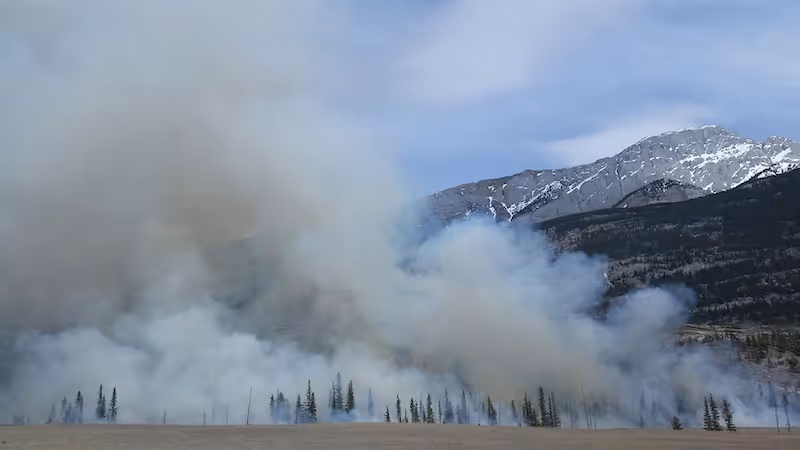
- Label distribution shifts are captured early: For example, a wildfire changes the landscape, which would affect the classification of vegetation and soil.
- Prevents label stagnation: Keeps the model aligned with up-to-date satellite imagery conditions.
A few considerations to make retraining safe and efficient:
- Keep a centralized annotation registry with version control for every label and its origin.
- Track model version lineage: What data was used for training and validation? What annotation batch improved it?
- Use incremental training methods (e.g., fine-tuning) rather than starting from scratch.
Tools like Weights & Biases or ClearML can help manage experiments and track changes across annotation and model cycles.
🧠 Active Learning in Earth Observation
Active learning takes model feedback one step further by making the model an active participant in what gets labeled next. It selects the data points that it’s least confident about and flags them for annotation.
In Earth Observation use cases, this helps when:
- You’re working with imbalanced classes (e.g., rare land use like salt flats or glacier melt zones).
- Your labeling budget is limited, and you want the most model-relevant examples annotated first.
- You need to bootstrap a model from a small initial dataset.
Top strategies for active learning:
- Uncertainty sampling: Label the examples where the model is least confident.
- Query by committee: Run multiple models and choose examples where they disagree.
- Diversity sampling: Choose data that looks different from what's already been labeled.
In practice, active learning helps prevent overfitting, reduce labeling costs, and improve generalization to new geographies or time frames.
🛠️ Automation for Model-Annotation Integration
To scale, these feedback loops need automation—not just processes. Here's how teams integrate automation for real-world impact:
- Scheduled inference jobs: Automatically run model predictions on new satellite imagery and enqueue for annotation.
- Webhooks for label updates: Trigger model retraining when a batch of reviewed labels is complete.
- Batch scoring dashboards: Show current model performance per region or class to help decide where human effort should go next.
By embedding these routines into your data pipeline, annotation and model development no longer happen in silos—they evolve as a system.
🌐 Case Example: Scaling a Deforestation Detection Model
A real-world implementation of model feedback loops was seen in a tropical forest conservation project. The team:
- Trained a YOLO-based object detection model to identify deforested patches from PlanetScope imagery.
- Used the model to generate pre-labels on new data every two weeks.
- Prioritized annotator effort on areas where the model flagged potential clearings but had <70% confidence.
- Retrained the model every month on the latest validated labels.
The result? Annotation efficiency improved by 65%, and model F1-score climbed from 0.58 to 0.89 in four months.
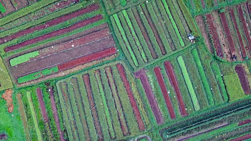
Handling Multisensor and Multiresolution Data
EO data isn’t just RGB. It spans multispectral, hyperspectral, SAR, LiDAR—and often across different resolutions (from 10m to 0.3m per pixel).
To scale annotation:
- Normalize all data into common tiling standards (like 256x256 or 512x512 px tiles).
- Store sensor metadata alongside image tiles to inform class boundaries and review logic.
- Build annotator profiles—train specific teams for specific sensor types.
This multi-resolution, multi-sensor orchestration is crucial for global-scale use cases like deforestation tracking or wildfire risk modeling.
Building the Right Team (and Keeping Them Productive)
Behind every scalable pipeline is a scalable team. Human expertise still drives annotation decisions, especially in EO where domain context is key.
Key roles in an EO annotation team:
- Domain specialists: for edge cases (e.g., snow cover, burnt area delineation).
- Annotation leads: for QA management and training.
- Data engineers: to maintain pipelines and automate workflows.
Tips to keep teams productive:
- Use micro-incentives and dashboards to show progress and reduce fatigue.
- Incorporate downtime retraining to upskill junior annotators.
- Rotate reviewers across regions to maintain fresh perspective and reduce bias.
Security, Governance, and Compliance Considerations
Scalability isn’t just about volume—it’s about responsibility. Earth Observation often touches sensitive topics: national borders, conflict zones, critical infrastructure.
Your pipeline should prioritize:
- Secure data handling: via encryption, access controls, and audit trails.
- GDPR/CCPA compliance: for human data used in labeling (e.g., annotator feedback, location).
- Transparent labeling governance: to track label lineage, review timestamps, and change histories.
Enterprises should consider using platforms that offer SOC2 or ISO 27001 compliance, and self-hosting if required.
Real-World Use Case Snapshots
Let’s explore a few cases where scalable annotation pipelines changed the game:
Flood Mapping at Scale
A climate analytics firm working with Sentinel-1 SAR imagery used pre-trained flood segmentation models to pre-label water zones. Annotators worked only on edge cases (e.g., distinguishing rivers vs. floods). With smart routing and active learning, they reduced full-manual labeling time by 75%.
Urban Growth Monitoring in Southeast Asia
A city planning agency used EO data to detect informal settlements. The annotation pipeline used seasonal tiling, active learning, and pre-labels. Review teams were split by country region, with escalation to urbanization experts. QA was layered with review queues and model feedback, maintaining 94% label precision.
Agricultural Field Boundary Mapping
A global agritech startup used Sentinel-2 + Planet imagery to label field boundaries. They trained generalists for well-defined crops (e.g., wheat) and specialists for fragmented zones (e.g., rice paddies in Indonesia). Their taxonomy evolved dynamically based on annotator feedback and model miss detections.
Future-Proofing Your Annotation Strategy
To truly scale, your EO annotation pipeline must:
- Support modular components for easy updates.
- Allow seamless AI integration to inject predictions and extract metrics.
- Be multi-tenant aware so different teams or clients can annotate in parallel.
- Enable hybrid human-AI QA with transparency at each step.
As satellite imagery gets more frequent (with platforms like PlanetScope) and richer (hyperspectral launches like CHIME), annotation pipelines must keep up—or risk bottlenecking innovation.
Let’s Scale Smarter 🚀
Whether you're detecting climate risk, planning sustainable cities, or mapping biodiversity from orbit, your Earth Observation AI is only as good as the data behind it. And the data is only as useful as its annotations.
A scalable annotation pipeline isn't just a backend process—it’s the foundation of your AI success.
Ready to accelerate your EO project? At DataVLab, we specialize in building enterprise-grade annotation pipelines tailored to the demands of Earth Observation. From sensor-specific workflows to active learning loops, we help you annotate better, faster, and smarter.
👉 Let’s connect and build something groundbreaking together.