Why Aerial Imagery is a Game-Changer for Real Estate 🏡🛰️
Aerial imagery has long been used in urban planning and land management, but recent advances in drone technology and satellite resolution have made it far more accessible and accurate. Combined with machine learning, these images allow real estate companies to automate what once required teams of surveyors and GIS specialists.
By integrating annotated aerial images into AI pipelines, companies can detect lot boundaries, assess land usage, and monitor development patterns at scale. This capability supports a wide range of functions—from streamlining property listing verifications to guiding municipal zoning decisions.
What makes this even more exciting is how annotation brings structure to this raw, top-down view of the world. When executed strategically, annotation allows AI models to detect land plots with high precision—even in densely built or irregularly segmented regions.
Real-World Use Cases That Benefit from Land Plot Detection
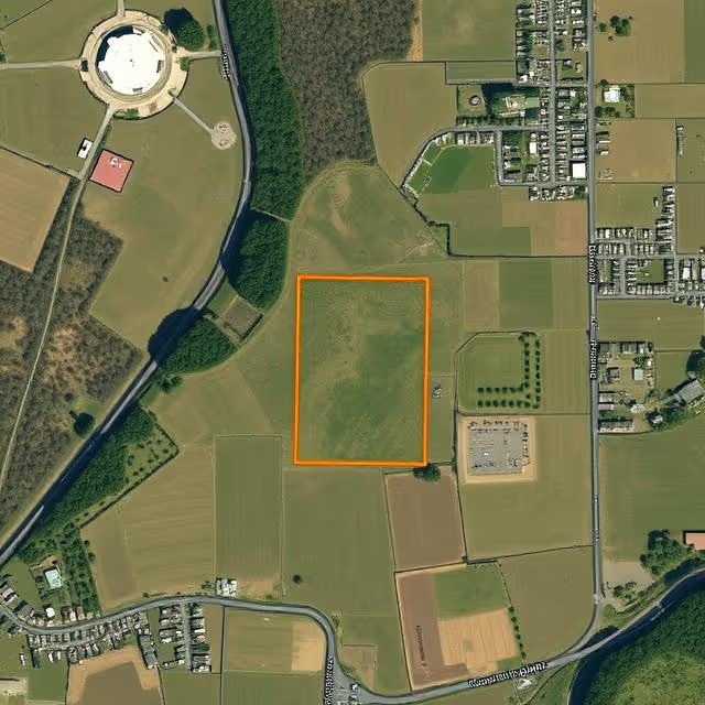
Automated Property Boundary Mapping
Accurate property boundaries are the cornerstone of any real estate transaction. Traditionally, boundaries are confirmed through physical surveys, a process that is not only costly but time-consuming. With aerial imagery annotated to highlight land plots, AI can automate boundary identification at scale.
This is especially helpful in:
- Fast-developing suburbs where plots are frequently subdivided
- Rural or agricultural zones where cadastral data is outdated or incomplete
- Informal housing areas with undocumented parcel divisions
Platforms like OpenStreetMap and Google Earth Engine can be integrated with annotated aerial images to enrich spatial data and support AI-based cadastral mapping initiatives.
Land Use Classification and Zoning Analysis
Governments and private firms alike need to understand how land is being used—whether it's residential, commercial, agricultural, or undeveloped. With annotated aerial images, AI models can classify and segment different land uses by plot.
Benefits include:
- Predicting urban expansion and infrastructure needs
- Validating zoning compliance before construction
- Enhancing environmental impact studies with plot-level insights
This use case is particularly critical for developing countries or regions undergoing rapid urbanization, where official zoning records are often missing or inaccurate.
Fraud Detection and Property Disputes
Land plot annotations offer a valuable layer of proof in high-stakes disputes over land ownership or encroachment. By training AI to detect discrepancies between official records and visible plot boundaries, platforms can flag anomalies automatically.
For instance:
- Detecting illegal extensions of properties
- Identifying boundary overlaps between neighbors
- Verifying the physical existence of advertised plots in digital real estate listings
Combined with legal cadastral data, AI-driven insights can significantly reduce fraudulent property activity and offer more confidence to buyers and regulators alike.
Construction Monitoring and Land Development Tracking 🏗️
By continuously analyzing aerial imagery over time, AI models trained on well-annotated datasets can monitor changes in land use, construction activity, and plot alterations. This is vital for:
- Real-time updates to real estate platforms
- Compliance monitoring by city planning departments
- Automated generation of "new development" leads for agencies and investors
Land plot annotations act as anchor points for comparing temporal changes, enabling systems to flag when a previously vacant lot becomes active or when development exceeds permitted limits.
Tackling the Challenges of Annotating Land Plots in Aerial Imagery
While the benefits are vast, land plot annotation in aerial views comes with its own technical and strategic hurdles.
Variability in Resolution and Scale
One of the most pressing issues is the inconsistency in resolution between satellite, drone, and plane-captured images. A high-resolution drone image may capture clear plot lines, while satellite images might blur those details. Annotators and AI systems must adapt to various resolutions by:
- Normalizing images to standard scales
- Using contextual features (like roads, fences, and vegetation lines) to infer boundaries
- Annotating multiple views (orthophotos and obliques) to compensate for occlusions
Irregular Plot Shapes and Encroachments
Unlike building footprints, which are often rectangular, land plots can be highly irregular. Natural terrain, informal development, and agricultural patterns create unusual plot boundaries that defy simple rectangular annotations.
To handle this:
- Polygon annotations are favored over bounding boxes
- Annotators may reference government maps or registry overlays
- Topological relationships (like adjacency, overlap) are encoded as metadata
These adaptations ensure AI models learn from the real-world messiness of land division, not idealized geometries.
Aligning with Geographic Information Systems (GIS)
AI models are only as good as the datasets feeding them. Yet, many aerial image datasets lack integration with GIS formats like shapefiles or GeoTIFFs. Annotation workflows must account for georeferencing requirements, enabling seamless alignment between visual data and spatial records.
This includes:
- Exporting annotations in geospatial formats
- Preserving coordinate metadata during annotation
- Using anchor points like road intersections or known landmarks for calibration
Data Pipeline Considerations for AI-Driven Land Plot Detection
For a robust AI system that can detect land plots from aerial imagery, annotation is just one part of the puzzle. Here's how the broader pipeline typically works:
Data Acquisition and Preprocessing
- Image sourcing: from satellite APIs, drone platforms, or aerial photography providers
- Preprocessing: includes resolution normalization, tilt correction, cloud masking
- Augmentation: creating variations via contrast shifts, brightness tweaks, and simulated weather conditions
Annotation Workflow Integration
Annotations should be structured in formats conducive to both training and inference. This typically means:
- Exporting polygons in GeoJSON or COCO-style datasets
- Associating plots with metadata (area, land type, cadastral ID)
- Handling multi-class labels for mixed-use parcels
Model Training and Validation
Object detection or instance segmentation models (e.g. YOLOv8, Mask R-CNN) are fine-tuned using annotated datasets. Key training practices include:
- Patch-based training on large aerial images
- Cross-validation with different geographic regions
- Incorporating topographical features as additional channels
Performance is usually validated using IoU metrics on held-out regions or through manual comparison with verified cadastral maps.
Deployment and Visualization
Once trained, models can be integrated into:
- Real estate SaaS platforms (for automatic land plot overlays)
- Government GIS dashboards
- Mobile apps for on-site surveyors and developers
Visual feedback loops ensure users can correct false positives or adjust boundaries as needed, improving the model’s future accuracy.
Impact on the Real Estate Ecosystem 🌍
The ripple effects of AI-driven land plot detection extend far beyond technical innovation—they're reshaping the very foundations of how the real estate industry operates. With aerial imagery and precise annotations fueling machine learning models, various stakeholders across the ecosystem are gaining unprecedented access to timely, reliable, and spatially accurate insights.
Real Estate Platforms: Smarter Listings, Better User Experience
Online property platforms are no longer just directories—they are intelligent search engines for homebuyers, investors, and renters. Land plot detection unlocks a new level of utility by:
- Overlaying accurate plot boundaries directly onto listing maps
- Filtering properties by parcel size or shape, not just by keywords
- Automatically verifying property existence via georeferenced imagery
- Highlighting landlocked or inaccessible plots that may be hidden in traditional data
These features improve user trust and engagement, particularly for remote buyers or international investors who can’t visit in person. Platforms like Zillow and Realtor.com are already exploring the integration of aerial insights to enrich their map views and suggest smarter investment options.
Surveying and Land Management Firms: From Fieldwork to Deskwork
Surveyors have historically relied on physical visits and manual tools to demarcate land boundaries. AI-driven land plot detection reduces this burden by:
- Providing pre-annotated aerial maps for initial assessments
- Identifying inconsistencies between official records and physical land use
- Supporting remote validation workflows, especially in hard-to-access or conflict-prone areas
This transformation allows surveyors to shift from boots-on-the-ground work to high-precision desktop verification, drastically reducing time, travel, and costs.
Government Agencies and Municipalities: Enforcing Zoning and Urban Planning
Land plot detection plays a pivotal role in public sector decision-making. Urban planners, zoning departments, and environmental agencies can:
- Monitor urban sprawl and illegal construction in near real-time
- Enforce land-use regulations using AI-generated evidence
- Speed up the issuance of construction permits by validating parcels automatically
- Update cadastral databases with fresh, satellite-backed intelligence
In countries where rapid urbanization or informal settlements challenge government capacity, this technology can bridge gaps in public infrastructure, transparency, and planning foresight.
Real Estate Developers: Precision in Site Selection and Risk Mitigation
For developers, location isn’t just everything—it’s everything and more. With annotated aerial imagery and AI analytics, developers can:
- Identify vacant or underutilized plots within targeted regions
- Evaluate land accessibility, topography, and shape before committing to a deal
- Detect proximity to risk zones (e.g., flood plains, fault lines, protected areas)
- Assess adjacent developments to understand market saturation or synergy
These insights reduce the risk of overpaying, underutilizing, or misclassifying a parcel, giving developers a clear edge during site selection and feasibility studies.
Investors and Financial Institutions: Informed Valuations and Due Diligence
Land valuation is notoriously complex, especially when records are incomplete or outdated. With AI-enhanced land plot detection:
- Banks can automate valuation baselines for mortgage approvals
- Private equity and VC firms can assess portfolio risk by analyzing the geographic spread of land-based assets
- Insurance companies can verify land features remotely for underwriting purposes
This makes investment decisions not only faster but also more data-driven and defensible, especially for large-scale acquisitions or development loans.
Environmental and Agricultural Stakeholders: Land Monitoring at Scale 🌿
Beyond the urban edge, annotated aerial imagery supports land-centric industries like Agriculture, conservation, and forestry. Plot detection models help:
- Track deforestation or reforestation efforts
- Monitor illegal land clearing or encroachment on protected zones
- Classify agricultural plots by crop type or irrigation level
- Support climate risk assessments tied to specific parcels of land
This layer of intelligence supports more sustainable and accountable land use—crucial in an era of rising environmental pressures.
Homebuyers and Property Owners: Transparency and Empowerment
For individual buyers, especially in developing markets, land transactions are often fraught with uncertainty. Who really owns the land? Where does the plot begin and end? With AI-detected plots layered over satellite views:
- Buyers can cross-check listings against aerial reality
- Owners can resolve disputes with neighbors using visual evidence
- Agents can educate clients visually, rather than relying on cryptic PDF maps or vague directions
This empowers individuals and democratizes access to high-quality property data—something traditionally reserved for experts and institutions.
When to Annotate and When to Automate?
An important strategic question is how to balance manual annotation with automation. In early-stage model development or new regions, manual annotation remains essential. But once a robust model is trained and validated, automation can take over routine labeling tasks, with humans in the loop only for exceptions.
An iterative workflow that cycles between annotation, training, and feedback is ideal for achieving both scale and quality. Image Annotation platforms offer tools for managing this active learning loop, ensuring that land plot detection gets more accurate with every image.
Wrapping It All Up (And Looking Forward) 🎯
The ability to detect land plots from aerial imagery using annotated data is transforming how real estate stakeholders operate—faster, smarter, and at unprecedented scale. With powerful AI models, high-quality annotations, and geospatial integration, what once took weeks on the ground can now be achieved in seconds from the sky.
As urban expansion accelerates, climate concerns grow, and transparency becomes a regulatory expectation, land plot detection will be foundational to both smart cities and ethical real estate practices.
Curious Where This Can Take Your Business?
Whether you're a real estate platform, government agency, or proptech startup, integrating land plot detection can offer a competitive edge. Let’s explore how annotated aerial imagery can elevate your operations—reach out, and we’ll help you take the leap 🚀