Why Illegal Deforestation Must Be Tracked—Now More Than Ever 🌍
Illegal deforestation is rampant across many parts of the globe, from the Amazon Basin to Southeast Asia and Central Africa. It accounts for more than 50% of all tropical deforestation, according to World Resources Institute. Beyond carbon emissions and habitat destruction, illegal logging often involves organized crime, corruption, and human rights abuses.
Here’s why rapid detection matters:
- Climate Regulation: Forests absorb 30% of carbon emissions; their loss accelerates global warming.
- Biodiversity Loss: Rainforests host more than half of the world's species.
- Cultural Devastation: Indigenous communities depend on forests for survival and identity.
- Regulatory Enforcement: Authorities need reliable data to stop illegal activity at its source.
Traditional monitoring methods—patrols, flyovers, and whistleblowers—are slow, expensive, and inconsistent. Satellite imagery offers a scalable, near real-time view of vast regions, but only AI can process the data fast enough to flag illegal changes.
The Role of Annotated Satellite Imagery in AI-Powered Forest Monitoring
To detect illegal deforestation, AI models must be trained to recognize specific land cover changes—what a healthy forest looks like vs. cleared patches, burned areas, or roads being cut into the canopy. This is where annotation becomes essential.
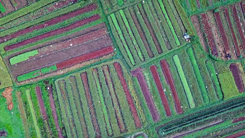
Imagine a Sentinel-2 image of a rainforest. To a human, it’s a mass of green. To an AI model, it’s just pixels—until someone annotates:
- Dense forest canopy
- Sparse vegetation or savanna
- Logging roads
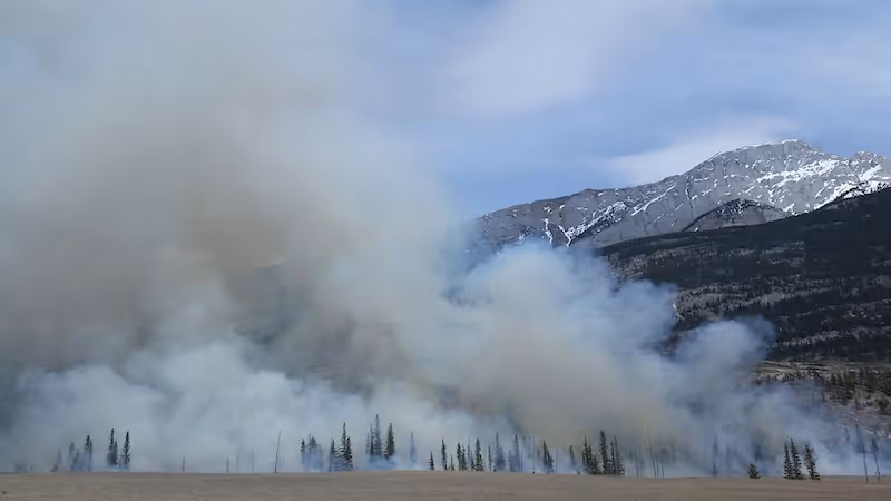
- Burn scars
- Clear-cut areas
By labeling these features on hundreds or thousands of images, annotators create the training datasets that AI models need to learn.
What Makes Deforestation Annotation So Complex?
While many assume that spotting deforestation is just a matter of “finding the brown spots” in a sea of green, annotating satellite imagery for this purpose is far more nuanced. The complexity arises from a mixture of environmental variability, technical challenges in satellite data, and the strategic efforts by illegal actors to avoid detection.
Subtle and Gradual Change Detection
Not all deforestation happens in large, obvious clear-cut patches. In many regions, illegal actors engage in:
- Selective logging, where only high-value trees are removed, leaving the canopy looking mostly intact.
- Edge clearing, where the outer rim of forest areas is slowly pushed back over time.
- Patchy patterns, designed to blend in with natural features.
These changes can be visually subtle, requiring annotators to focus on minute variations in texture, color gradients, or geometric shapes such as zigzagging roads and clearings.
Temporal Complexity
Satellite monitoring depends on capturing changes over time. Annotators often work with multi-temporal datasets, comparing imagery from multiple dates to spot change. But aligning and annotating such sequences poses challenges:
- Seasonality: Rainforests often look vastly different in the wet and dry seasons. Deciduous trees may shed leaves, muddy water may obscure features, and lighting can shift dramatically.
- Agricultural interference: Fields may appear to change rapidly due to crop rotation or legal clearing, making it harder to distinguish from illicit forest loss.
- Time lags in satellite revisits: Some areas may only be imaged every 10–15 days, creating a blind spot that deforesters can exploit.
Multi-Sensor Complexity
Annotators often work with multispectral or radar data rather than RGB imagery alone. This adds significant complexity:
- Near-Infrared (NIR) and Short-Wave Infrared (SWIR) bands are crucial to detecting vegetation health and burn scars.
- Synthetic Aperture Radar (SAR) can detect deforestation even through clouds, but interpreting SAR data is technically demanding.
- Annotators may need to correlate multiple layers (optical, radar, vegetation indices) to draw accurate boundaries.
Class Ambiguity and Legal Boundaries
What constitutes “illegal” deforestation isn't always clear from imagery. Annotators must distinguish between:
- Authorized timber harvesting vs. unsanctioned clearing
- Natural events (like landslides or wildfires) vs. anthropogenic activity
- Shifting cultivation by local communities vs. industrial-scale land grabbing
This requires access to external datasets such as land use rights, forestry permits, protected area boundaries, and historical context—often unavailable or inconsistent across countries.
Geographic Diversity
Different forest ecosystems behave differently:
- Tropical rainforests (Amazon, Congo Basin, Borneo) have dense, evergreen canopies.
- Temperate forests show seasonal variation.
- Dry forests and mangroves present unique spectral signatures.
Training AI on one type of forest may not generalize to another, so annotations must be diverse and representative of the global range of conditions.
Socio-Political Sensitivity
Annotators often work in high-stakes environments:
- Governments or companies may contest the classification of “deforested” areas.
- Mislabeling a legally cleared area as illegal (or vice versa) could result in litigation or diplomatic fallout.
- Annotators may face pressure from stakeholders, especially in conflict-prone or resource-rich regions.
In such contexts, annotation isn’t just a technical task—it becomes an act of environmental governance, requiring accuracy, neutrality, and careful documentation.
Building AI Models for Deforestation Detection: A Data-Driven Process
Once annotations are complete, AI pipelines follow a series of carefully crafted steps:
1. Preprocessing and Data Augmentation
Before training, satellite imagery must be corrected for atmospheric conditions, resampled, and normalized. Data augmentation (rotation, contrast changes, band selection) improves model generalization.
2. Model Architecture Selection
Most environmental AI models rely on:
- CNNs for semantic segmentation (e.g., U-Net, DeepLab)
- Temporal models (e.g., ConvLSTM, Transformer variants) for time series analysis
- Self-supervised learning for leveraging unlabeled data
3. Validation with Ground Truth
Whenever possible, AI predictions are compared with:
- Government forestry records
- Drone images
- On-the-ground GPS-tagged photos
This validates model accuracy and flags potential bias or gaps in the data.
4. Deployment into Monitoring Systems
Trained models are integrated into platforms like:
These systems can then issue real-time alerts for suspected illegal activity, enabling enforcement or mitigation.
Overcoming Real-World Challenges 🌦️
Even with excellent models, real-world deforestation detection involves unique hurdles:
Cloud Obstruction
Tropical regions have near-daily cloud cover. Annotated datasets must include cloud masks and leverage radar-based sensors (e.g., Sentinel-1 SAR) that can see through clouds.
Access to High-Resolution Imagery
Illegal operations may occur at small scales—e.g., clearing <1 hectare. Public imagery often lacks the resolution needed to detect these changes. Many initiatives now combine:
- Public data (e.g., Landsat, Sentinel-2)
- Commercial sources (e.g., Planet, Maxar)
- Drones for validation
Political Sensitivity
AI-powered alerts can have geopolitical implications. Mislabeling legal forestry as illegal—or vice versa—may lead to diplomatic tensions. High-quality, audited annotation is critical to avoid false accusations.
Global Projects Tackling Illegal Deforestation with AI 🌐
Around the world, a growing number of organizations are combining annotated satellite imagery with advanced AI to fight back against illegal deforestation. These efforts are as diverse as the ecosystems they protect—from the Amazonian rainforests to the boreal zones of Russia and the mangroves of Southeast Asia.
Rainforest Alert System – Rainforest Foundation US
The Rainforest Foundation US collaborates with indigenous communities in the Amazon to detect and act on deforestation alerts using radar-based change detection.
Key features:
- Powered by the RADD (Radar for Detecting Deforestation) system.
- Uses Sentinel-1 SAR data, which works through clouds.
- Annotated training data helps the system recognize logging roads, canopy openings, and burned areas.
- Alerts are sent directly to local forest guardians via apps and SMS.
- Results: In areas with alerts, illegal deforestation was reduced by up to 52% within the first six months.
MAAP – Monitoring the Andean Amazon Project
Amazon Conservation’s MAAP publishes real-time alerts and in-depth reports on illegal deforestation, mining, and burning.
What sets MAAP apart:
- Leverages PlanetScope high-resolution daily imagery.
- Combines manual annotation with automated analysis.
- Generates public evidence-based reports used by journalists, activists, and policy makers.
- Documents specific actors (e.g., gold miners, agribusiness) with geo-referenced imagery.
This initiative has helped strengthen enforcement in Peru and inform international policy debates.
Global Forest Watch (GFW)
Global Forest Watch by the World Resources Institute is one of the largest platforms for forest change data.
GFW combines:
- Public satellite imagery (e.g., Landsat, MODIS, Sentinel)
- Custom AI models trained on annotated datasets for tree cover loss
- Alerts through the GLAD system (Global Land Analysis & Discovery)
Users—from national governments to journalists—can:
- Subscribe to deforestation alerts by area
- Explore trends over time
- Download labeled data for further analysis
GFW supports open-access initiatives and enables citizen science participation.
Norway’s NICFI & Planet Partnership
Through NICFI, the Norwegian government funds global access to high-res tropical forest imagery from Planet Labs.
Why this matters:
- Provides free access to sub-5m resolution imagery of tropical forests.
- Fuels the development of annotated datasets for dozens of NGOs and academic projects.
- Enables local governments to track compliance with anti-deforestation pledges under REDD+ and other climate accords.
Annotation projects supported by NICFI are often open-source and collaborative, helping expand the global training data pool.
Google Earth Engine (GEE) + AI Initiatives
GEE offers a vast library of geospatial datasets and cloud computing tools. Several AI projects use Earth Engine’s data catalog, including:
- Brazil’s MapBiomas project, which uses AI and annotation to classify land use and cover.
- Code for Africa’s forest monitoring tools, leveraging both satellite data and crowdsourced labels.
By using GEE’s processing power, these initiatives can scale their models to continental or global levels.
FAO’s SEPAL and Collect Earth
The UN FAO developed SEPAL (System for Earth Observation Data Access, Processing & Analysis for Land Monitoring) and Collect Earth, a visual annotation tool for forest monitoring.
- Analysts use Collect Earth to manually annotate sample plots in satellite imagery.
- Data feeds into AI models for national forest inventories and REDD+ verification.
- These programs bridge the gap between human oversight and machine prediction.
How Good Annotation Improves Environmental AI Outcomes
Here’s why annotation quality makes or breaks forest monitoring AI:
- Precision: Reduces false positives (e.g., mistaking savanna for deforestation)
- Recall: Improves detection of small, fragmented, or camouflaged clearings
- Transferability: Allows models to generalize across forest types and regions
- Ethical Trust: Minimizes harm by ensuring that flagged areas are accurately identified before action is taken
Annotation isn’t just a technical task—it’s an ethical responsibility when human livelihoods and national policies are at stake.
A Growing Ecosystem of Environmental Annotation Efforts 🌱
As awareness and funding increase, so does the need for skilled annotation teams that specialize in geospatial data. These efforts are supported by:
- NGOs training local communities to annotate imagery
- Universities developing open-source datasets and benchmarks
- Private sector companies offering annotation services tailored to environmental AI
Crowdsourcing, while effective for some types of data, often struggles with the domain expertise required in satellite imagery. Instead, hybrid annotation models—where experts label core examples and automation assists in scaling—are gaining traction.
What’s Next for AI-Driven Deforestation Monitoring?
The next evolution of deforestation AI will likely include:
- Real-time, edge-based analysis on satellite ground stations
- Fusion of radar + optical data for more robust detection
- Synthetic data generation to enhance rare-case learning (e.g., fire-driven clearing)
- Integration with blockchain for transparent forestry audit trails
- Increased community involvement in both annotation and response
The future isn’t just about better models—it’s about building collaborative ecosystems that bring together AI experts, environmentalists, policy-makers, and indigenous communities.
Let’s Protect the Forests—Together 🌿
Satellite imagery and AI give us incredible power to monitor deforestation like never before. But that power depends on annotated data—the invisible, painstaking labor behind the models.
If you’re working on an environmental AI project, need support with satellite imagery annotation, or want to explore a partnership for forest monitoring, we’d love to help.
👉 Get in touch with the team at DataVLab to discuss how we can support your AI goals with high-quality, mission-critical annotation.
Together, we can turn pixels into protection—and technology into lasting change.